 |
| The area borders the desert and San Diego County. |
 |
| Southern California Map. |
 |
| Driving Map. |
Trailhead coordinates: 33.4798°N, -116.8625°W.
Summary
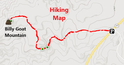
Takes somewhat of a keen eye to determine where to start the hike. It is at a locked vehicle gate off the side of Highway 371. This unheralded hike gets very few visitors, evident by the fact that I was out there all alone on my visit. The old roadway goes through the hilly plateau before eventually elevating to the high point known as Billy Goat Mountain.
Hiking Stats:
 |
| Hiking Map. |
Takes somewhat of a keen eye to determine where to start the hike. It is at a locked vehicle gate off the side of Highway 371. This unheralded hike gets very few visitors, evident by the fact that I was out there all alone on my visit. The old roadway goes through the hilly plateau before eventually elevating to the high point known as Billy Goat Mountain.
 |
| On the summit. |
The high point has large boulders, making standing on top of the highest boulder necessary for claiming the summit. Good views into the Inland Empire and to the nearby Palomar Mountains to the south. Out and back is a quick outing, and if planned will could be combined with other nearby hikes to round out a day of hiking.
Video:Simulated Hike:
 |
| Getting ready to scamper up the summit boulder. |


No comments:
Post a Comment