Purpose of the site

This blog will detail 1,000 video hikes in Southern California. By Southern California, I am drawing a line from San Luis Obispo to the Nevada Border. Anything south of that line will be declared "Southern California". In a way, it is a personal challenge to do so many hikes. Mainly, however, it is my way of showcasing how many hiking opportunities there really are right in our own geographic back yard. As a blog, it serves as a companion piece to my Youtube channel "1,000 Hikes in So Cal". It is also a work in progress, as I don't actually have 1,000 edited videos completed. This will take effort for quite some time before it is declared done. Even then, there will still be more out there. Here's to hiking and all the positive effects it has had on my life...and possibly yours!

Showing posts with label Santa Ana Mountains. Show all posts

Saturday, October 8, 2022

#146 Sierra Peak

Looking toward the mountain top.


Southern California Map
Driving Map.
Overall Hiking Totals:
Hiking Map.
Parking coordinates: 33.85012°N, -117.6537°W.
Summary
The hike to Sierra Peak is long, no matter where the starting point is.  There are two routes that are along dirt roads, which makes it ideal for visiting via mountain bike. However, if a mountain bike can do it, so can a hiker.  The hike I completed started on the Santa Ana River Bike Trail in Corona. 
Views from Grassy Peak.
It did seem kind of awkward whenever bike riders passed by in this more than one mile segment of the hike.  It eventually breaks off to the south and passes under the 91 Freeway, where it eventually turns into a dirt road.  The hike passes through a little known section of  Chino Hills State Park, where I briefly visited Grassy Peak.
On the summit of Grassy Peak.
Grassy Peak was a minor victory, with much more gradual climbing to follow.  It quickly leaves Chino Hills State Park and enters Coal Canyon Ecological Reserve. to a high point on the ridge, known as Mini Moab Peak. 
Mini Moab Peak
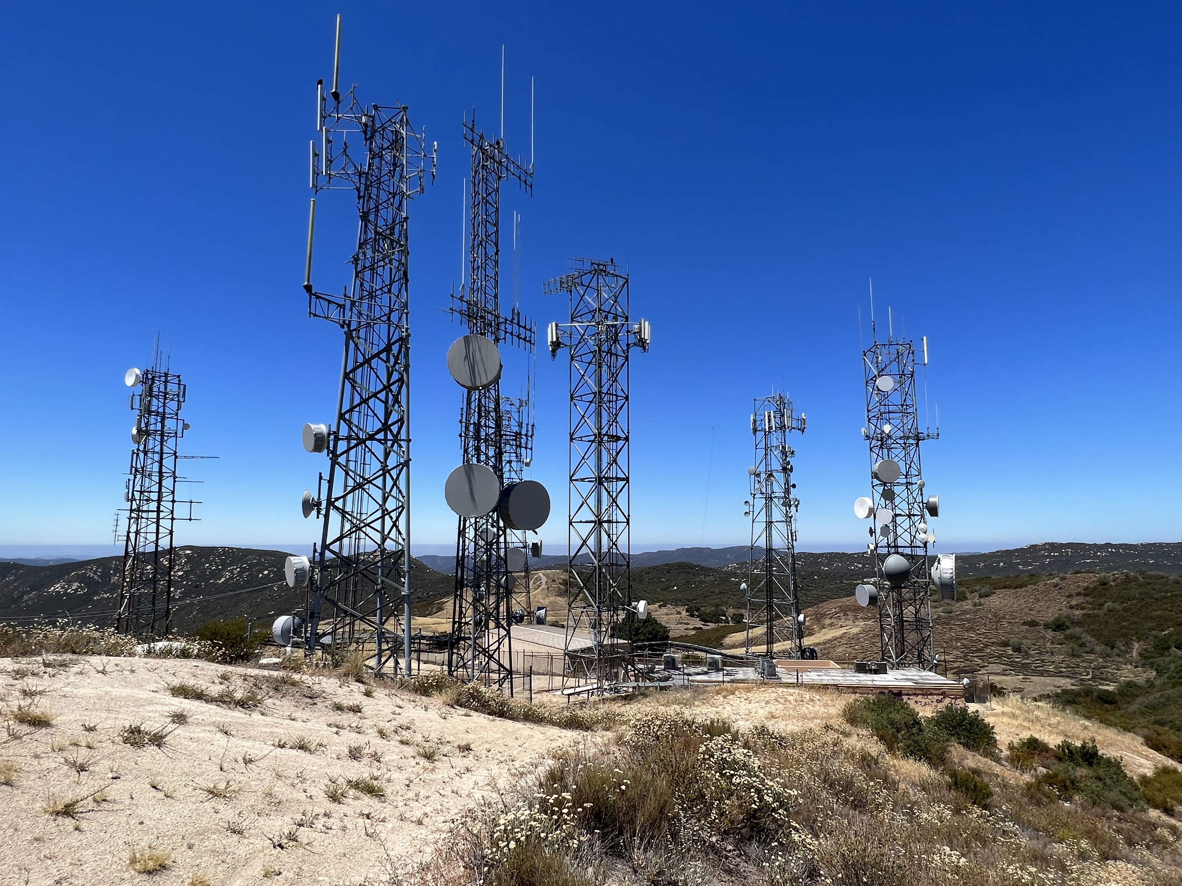
A slight off trail led me to the high point.  I picked up Leonard Road from there and proceeded toward Sierra Peak.  It officially enters Cleveland National Forest along the way.  On top are numerous radio towers and good views. 
Approaching Sierra Peak.
After eating my sandwich, I headed down the same way.  I could have taken the Pipeline Trail down to form a loop, but I remember it being steep and rather hard on the knees, so I bypassed it and opted for more mileage (it only would have saved about 1.5 miles).
On the summit.
However, since the return the way I came was a gradual downhill, it was more of a long pleasant stroll than taxing, due to the mileage.
Summit benchmark.
Still, It felt rather awkward on the bike path in the remaining stages of the hike, but it was nice to look back up at the mountain as I walked beneath it, realizing that I had conquered it. Also there was no true reason to feel awkward, since I wasn't one of the bike riders on an easy flat ride, I actually did something on the day!
Video:
Simulated Hike:

Sunday, July 3, 2022

#127 Easy Hikes to Lake Elsinore Overlooks

The money shot overlooking Lake Elsinore.
Southern California Map.
Overall Hiking Totals:

Peak 3106 Hiking Map.
Parking coordinates: 33.6025°N, -117.3433°W.
Summary
Heading up Peak 3106 from Main Divide Road.
Highway 74, also known as Ortega Highway, Climbs steeply west of Lake Elsinore into the Santa Ana Mountains.  Once at this high vantage point, overlook opportunities reveal themselves.  There are a few nice roadside overlook points with memorable photo opportunities.  However, with a desire to hike to other good vantage points, I chose to seek out some of the less crowded and harder to get to overlooks of the lake. Naturally, the benefit of doing so for me was to get some sunshine and exercise to go with it.
On the summit of Peak 3106.

The first was Peak 3106.  From a parking turnout on Main Divide Road (about 2 miles south of Ortega Highway), paragliders launch from the bluff above. A well defined use trail goes from the pullout and leaves the bluff behind. The trail climbs to a high point overlooking Lake Elsinore. A white pole stands next to the summit boulder with outstanding lake views below. Although my duo of hikes on the day were short, this one was clearly my favorite. I would even go as far to say that this is one of the more underrated hikes in the Santa Ana Mountains.
Heading up the utility road to Elsinore Peak.
The second overlook point was none other than Elsinore Peak.  There is a locked vehicle gate at the start of what is merely a dirt utility road leading to the summit.  The hike is a gradual climb but short.  Before the summit are communication towers and utility buildings. 
On the summit looking down on the towers.
Just beyond, is the actual summit, marked with a benchmark.  From that point, there are great views overlooking Lake Elsinore from an even higher vantage point than Peak 3106.
Overlooking Lake Elsinore.
The hikes in total took only about 2 hours. Both hikes were 1.1 miles out and back.  Although the time spent was minimal, memories and an overall good time is long remembered.
Video:

Sunday, January 2, 2022

#65 Chiquito Falls (via Chiquito Trail)

The hike starts on the San Juan Loop.

Southern California Map
Driving Map.
Parking Map.
Google Maps Trailhead Link
Trailhead coordinates: 33.6133°N, -117.4268°W.
Hiking Stats:

Hiking Map.
Summary
The hike to Chiquito Falls is a long one to reach a small waterfall.  It is also best to visit in the wet part of the rainy season in order to actually see the waterfall flowing.  Despite these limitations, the hike is very scenic and the rewards can be great if timing it just right.  There are actually two different trails, each of similar length and difficulty, which reach Chiquito Falls.  The other route is via the San Juan Trail, which I hope to add to the list at some time in the future.
Overlooking San Juan Falls.
Via the Chiquito Trail, the hike begins by completing half of the San Juan Loop.  It includes a quick visit to San Juan Falls in the process.  After the falls, it descends into the canyon and through the scenic oak trees.  The climb begins after crossing the creek.  The trail climbs to a high point before descending to Chiquito Falls in an upper canyon.
Low flowing Chiquito Falls.
I didn't time this one well into a dry rainy season, so the waterfall was merely a trickle.  If I include the San Juan Trail to the falls in the future, I will plan it accordingly so as to insure a good flowing waterfall. On the way back, the other half of the San Juan Loop gets completed, thus essentially wrapping up two trails in one hike.
Scenic oaks on the San Juan Loop.
Video:
Simulated Hike:

Friday, December 31, 2021

#60 Los Pinos Peak

View of Lake Elsinore from a lower summit.

Southern California Map.
Driving Map.
Parking Map.
Google Maps Trailhead Link
Trailhead coordinates: 34.6642°N, -117.4712°W.
Hiking Stats:

Hiking Map.
Summary
New Year's Eve gave me my last chance to get in a hike before the end of the year.  Although the weather wasn't ideal, I made Los Pinos Peak my chosen hike.  There is very little shade on this hike, so the cloud cover certainly kept the heat away.  The hike goes up Main Divide Road to Munhall Saddle.  Along the way, I also summited one lower peak and Vicker Benchmark before reaching Munhall Saddle.
On the lower summit looking toward the ridge.
At Munhall Saddle, the Los Pinos Trail is accessible.  On the way up the Los Pinos Trail I entered the clouds and made a foggy ascent of the ridge.  I took photos of the summit, but had no view.  That was the only drawback to an otherwise completely satisfying hike.  Fog is the exception to the rule, though.  Normally there are blue skies and warm weather in this low elevation mountain range.
On the summit of Vicker Benchmark.
I returned the way I came and descended through the clouds.  I still had time to go to a second location if I wanted to, but this was a fitting ending to a hiking year, as I emerged from the clouds to conclude the experience.
Los Pinos Peak.
Video:
Simulated Hike:

Saturday, November 6, 2021

#46 Sitton Peak

Approaching Sitton Peak.
Southern California Map.
Driving Map.

Parking Map.
Google Maps Trailhead Link
Trailhead coordinates: 33.61236°N, -117.42652°W.

Hiking Stats:


Hiking Map
Summary
I find myself drawn to this part of the Santa Ana Mountains in the fall.  Sitton Peak is a hike that I had intended to revisit at some point, and it became obvious that today was the day.  I accessed the Bear Canyon Trail and passed through the scenic canyon.  At Five Points Junction, it is a sharp right to access the Sitton Peak Trail.  The wide trail continues toward Sitton Peak.
On the summit.

The retired dirt road provides a wide thoroughfare for hiking. It winds up going through the hills before leading to a summit access trail.  The narrow access trail is steep and rather unforgiving on up to the peak.  The summit had a few summit signs, a register, and great views.

Summit benchmark.

I returned the same way to Five Points.  At just past the junction, I ascended the slope to the right on a use trail to reach Boy Scout Peak.  It is a wide summit, so views really aren't very memorable from the high point.

On top of Boy Scout Peak.
On the way back to Five Points, I picked up the North Tenaja Trail to see if I could visit another nearby peak of Bear Ridge,  Unfortunately, this side trek proved to be unsuccessful since I could not find any access trail and was unwilling to bushwhack.
Descending back to Five Points.
When I was ready to give up, I simply returned to Five Points.  Still up for a little variety, I took the alternative Bear Ridge Trail.  This trail goes parallel to Bear Canyon, but is mostly on the ridge above Bear Canyon.  It later reconnects with the Bear Canyon Trail before returning to the parking lot at Ortega Oaks.
Looking back at Boy Scout Peak.
Video:


Simulated Hike:


#159 Guatay Mountain

Looking up the side of the mountain. Southern California Map. Driving Map. Overall Hiking Totals: Hiking Map. Google Maps Trailhead Link Par...