 |
| The hike starts on the San Juan Loop. |
 |
| Southern California Map |
 |
| Driving Map. |
 |
| Parking Map. |
Trailhead coordinates: 33.6133°N, -117.4268°W.
Summary
The hike to Chiquito Falls is a long one to reach a small waterfall. It is also best to visit in the wet part of the rainy season in order to actually see the waterfall flowing. Despite these limitations, the hike is very scenic and the rewards can be great if timing it just right. There are actually two different trails, each of similar length and difficulty, which reach Chiquito Falls. The other route is via the San Juan Trail, which I hope to add to the list at some time in the future.
Hiking Stats:
 |
| Hiking Map. |
The hike to Chiquito Falls is a long one to reach a small waterfall. It is also best to visit in the wet part of the rainy season in order to actually see the waterfall flowing. Despite these limitations, the hike is very scenic and the rewards can be great if timing it just right. There are actually two different trails, each of similar length and difficulty, which reach Chiquito Falls. The other route is via the San Juan Trail, which I hope to add to the list at some time in the future.
 |
| Overlooking San Juan Falls. |
Via the Chiquito Trail, the hike begins by completing half of the San Juan Loop. It includes a quick visit to San Juan Falls in the process. After the falls, it descends into the canyon and through the scenic oak trees. The climb begins after crossing the creek. The trail climbs to a high point before descending to Chiquito Falls in an upper canyon.
 |
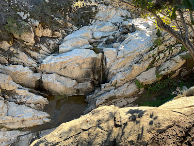
| Low flowing Chiquito Falls. |
I didn't time this one well into a dry rainy season, so the waterfall was merely a trickle. If I include the San Juan Trail to the falls in the future, I will plan it accordingly so as to insure a good flowing waterfall. On the way back, the other half of the San Juan Loop gets completed, thus essentially wrapping up two trails in one hike.
 |
| Scenic oaks on the San Juan Loop. |
Video:Simulated Hike:


No comments:
Post a Comment