This blog will detail 1,000 video hikes in Southern California. By Southern California, I am drawing a line from San Luis Obispo to the Nevada Border. Anything south of that line will be declared "Southern California". In a way, it is a personal challenge to do so many hikes. Mainly, however, it is my way of showcasing how many hiking opportunities there really are right in our own geographic back yard. As a blog, it serves as a companion piece to my Youtube channel "1,000 Hikes in So Cal". It is also a work in progress, as I don't actually have 1,000 edited videos completed. This will take effort for quite some time before it is declared done. Even then, there will still be more out there. Here's to hiking and all the positive effects it has had on my life...and possibly yours!
Showing posts with label Moderate to Strenuous. Show all posts
Showing posts with label Moderate to Strenuous. Show all posts
The hike to Sierra Peak is long, no matter where the starting point is. There are two routes that are along dirt roads, which makes it ideal for visiting via mountain bike. However, if a mountain bike can do it, so can a hiker. The hike I completed started on the Santa Ana River Bike Trail in Corona.
Views from Grassy Peak.
It did seem kind of awkward whenever bike riders passed by in this more than one mile segment of the hike. It eventually breaks off to the south and passes under the 91 Freeway, where it eventually turns into a dirt road. The hike passes through a little known section of Chino Hills State Park, where I briefly visited Grassy Peak.
On the summit of Grassy Peak.
Grassy Peak was a minor victory, with much more gradual climbing to follow. It quickly leaves Chino Hills State Park and enters Coal Canyon Ecological Reserve. to a high point on the ridge, known as Mini Moab Peak.
Mini Moab Peak
A slight off trail led me to the high point. I picked up Leonard Road from there and proceeded toward Sierra Peak. It officially enters Cleveland National Forest along the way. On top are numerous radio towers and good views.
Approaching Sierra Peak.
After eating my sandwich, I headed down the same way. I could have taken the Pipeline Trail down to form a loop, but I remember it being steep and rather hard on the knees, so I bypassed it and opted for more mileage (it only would have saved about 1.5 miles).
On the summit.
However, since the return the way I came was a gradual downhill, it was more of a long pleasant stroll than taxing, due to the mileage.
Summit benchmark.
Still, It felt rather awkward on the bike path in the remaining stages of the hike, but it was nice to look back up at the mountain as I walked beneath it, realizing that I had conquered it. Also there was no true reason to feel awkward, since I wasn't one of the bike riders on an easy flat ride, I actually did something on the day!
The hike starts at Dawson Saddle, which leads to a high ridge, featuring some of the highest peaks in the San Gabriel Range. The first of which is Throop Peak. I had visited this summit a few times in the past, and I was happy to include it on this outing.
Summit use trail to Throop Peak.
The trail connects with the Pacific Crest Trail just below the summit. I left the PCT pretty much right after I got on it by taking a summit use trail to the top of Throop Peak. The summit elevation is 9,138, which is also the highest point on the hike.
Summit plaque on Throop Peak.
I descended the opposite slope of Throop to quickly return to the PCT, where I continues Southwest toward the Mt Hawkins. Once again, a summit use trail leaves the PCT to reach Mt Hawkins.
Approaching the summit on the use trail.
However, this time it wasn't optional, this was also part of the route. After topping on Mt Hawkins, I paused for a few minutes as I looked down the ridge the dropped from the summit to the south. Although walking downslope would be in my immediate future, I would have to climb back up it as well, so I needed to mentally prepare to maintain the energy on the way back.
Heading down the ridge.
I left Mt Hawkins to the south and continued down the slope on a use trail. As expected, the route was not difficult to descend, though there were some obstacles such as downed trees to navigate around. At the far end of the ridge, it is considered to be the summit of Copter Ridge.
On the summit of Copter Ridge.
A summit register sits there with a great view of the surrounding peaks and ridges. The elevation is at 7,500 feet. This made for a great lunch spot for the needed fuel to climb back up. When the time came, off I went with a head of steam back up the ridge.
Summit view of the ridge route back.
Mental preparation certainly paid off, as I was prepared for the long climb. Before long, I crossed back over Mt Hawkins, thereby conquering the ridge. I then returned along the PCT and back down the Dawson Saddle Trail to complete the triple peak hike.
Summary The hike begins in a well-to-do Palm Springs neighborhood. It climbs quickly into the hills above. Once leveling off, it is possible to form a loop on the plateau, which I did. I saved Cahuilla Peak for last, which was just to the left of the intersection of trails. I went right on the Wildhorse Trail to begin the loop. The first peak reached was Wildhorse Peak. The trail heads up its rocky ridge to a prominent summit. The feeling of accomplishment was brief when looking at the rest of the ridge laid out in front.
Palm Springs views.
The Wildhorse Trail continues on the ridge toward Murray Hill. A left turn on the Clara Burgess Trail becomes necessary along the way. The hike rises from the junction to the summit of Murray Hill. On top are picnic tables, a benchmark, and great views. The prominent high point is a great resting spot for a quick snack before heading on.
Wildhorse Peak.
I chose to continue forward to form a loop, rather than returning the way I came. The trail drops quickly toward the canyon floor before continuing on to Cahuilla Peak.
Murray Hill.
I found the trail to not be too well marked in the canyon, but I eventually figured out the right pathway to take. Arrival at Cahuilla Peak, and to the junction just beyond it, marked the completion of the long dry loop of the ridge and canyon floor. After the loop, I still needed to descend to Palm Springs to close out the hike. Fortunately, I didn't run out of water, but I came close!
By the time I reached this day, I felt like a lion confined in a cage. I had limited myself to easy hikes essentially since the beginning of the year. Truly, there was low hanging fruit as I intended to get all the local easy hikes documented on video. Meanwhile, I wanted to do something a little more challenging. Recently, I noticed local San Gabriel Mountain peaks that I had not yet visited appear on the Peakery database. I was determined to get them added to my completed list, so off I went when the weekend hit.
Transplanted Castro Peak Fire Lookout.
The hike begins in Eaton Canyon. Instead of beginning at the overcrowded Eaton Canyon Trailhead, there is a closer starting point in an Altadena neighborhood at the Mt Wilson / Pinecrest Gate. From there, the roadway crosses Eaton Canyon and then climbs the old Mt Wilson Toll Road toward Henninger Flats. There is nearly no shade at all on the approach to Henninger Flats. While there, I took a look at the old Castro Peak Fire Lookout, which sits on display there. The museum was closed this time around, but that was OK, I was only about half way to my daily goal.
Hiking up the road.
The road continues past the shady Henninger Flats and higher into the range. At about 5.5 miles into the hike, the hike meets a use trail that rises up the slope to the south of the roadway. It leads to a good viewpoint over the San Gabriel Valley. This was the summit of Mt Fuji.
Mt Fuji summit & Mt Princeton in the background.
Not sure if this was named because it was the peak that Godzilla looked over before sacking Los Angeles in an old movie. This gave me something to contemplate as I continued to Mt Princeton.
Approaching Mt Princeton.
About a mile beyond, the road meets a saddle between Mt Princeton and Mt Yale. I had been at this spot before when doing the Mt Yale hike, except I had arrived from the NE instead of the SW as I did this time. I took a right turn and went up a firebreak to the summit of Mt Princeton. From the summit there are good valley views and of the rest of the range.
On the summit overlooking the San Gabriel Valley.
This was my true turnaround point. Since I didn't use a good tracking app, I'm not positive of the mileage to get there, It was somewhere between 6.5 to 7.5 miles. So by heading back down, I doubled my mileage back to Pinecrest Gate. More front range peaks in the San Gabriel's get checked off!
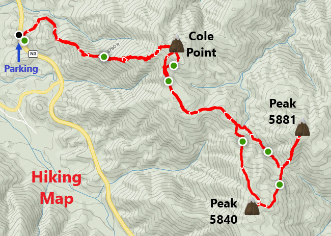
Near mile marker 7.10 on Angeles Forest Highway, I walked up a dirt road heading east. The dirt road continued for about 0.4 miles before reaching a use trail on the left. The use trail climbs the lower slope of Cole Point. It is a short but steep climb up the trail, which occasionally disappears along the way. However, the direction of "up" is pretty clear, so it is easy to stay on track despite the inconvenience of the occasional cross-country scrambling. The summit of Cole Point is reached in about 1.5 miles. On my visit, the summit had been recently bulldozed as part of a firebreak project in the San Gabriel Mountains.
On the summit of Cole Point
Although this is the main peak to visit on the hike, there are still two more within hiking distance. I took up the challenge and went on to get them both. They are visible from Cole Point to the east. I continued along new firebreaks toward them. The first up was Peak 5840. A very steep ascent was necessary along the no nonsense firebreak. A witness post marks the summit.
On the summit of Peak 5840.
The next peak over, Peak 5881, is the final peak on the hike. To get to it involves a long dip on the firebreak followed by a steep climb to the summit.
Approaching Peak 5881.
Despite being the high point on the hike, the freshly bulldozed summit seemed more like a construction site. Despite that, the area seemed far removed from people. Once again, I chose another remote and seclusive location (no regrets). It is not the most scenic of areas, but the fresh air certainly helps. On the way back, there is some climbing to get back up Cole Point, however, once there, it is downhill all the way back down to Angeles Forest Highway.