 |
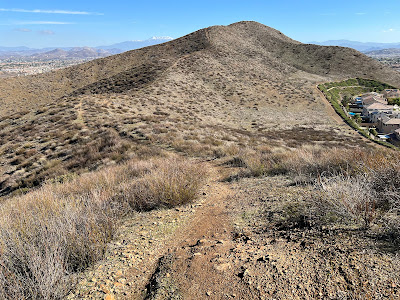
| Some climbing to do to reach Peak 2001. |
 |
| Southern California Map. |
 |
| Driving Map. |
 |
| Parking Map. |
Trailhead coordinates: 33.6711°N, -117.2319°W.
Summary
With New Year's Day in full swing, this one turned out to only be the second hike of a 4 hike day. Normally an early start is essential for beating the heat in the Inland Empire. However, since this was the winter, temperatures were ideal the entire day. The hike began from Heather Ridge Road. This is where I chose to start, there is another potential starting point in a nearby Menifee neighborhood.
Hiking Stats:
 |
| Hiking Map. |
With New Year's Day in full swing, this one turned out to only be the second hike of a 4 hike day. Normally an early start is essential for beating the heat in the Inland Empire. However, since this was the winter, temperatures were ideal the entire day. The hike began from Heather Ridge Road. This is where I chose to start, there is another potential starting point in a nearby Menifee neighborhood.
 |
| The summit of Peak 2001. |
From Heather Ridge Road, I picked up a use trail found in a wide break between two homes. Once dipping further in, the use trail became much wider and clear. The trail led up to the ridge between the two peaks. I wanted to do the higher peak first, so up Peak 2001 I went. The trail is very good on the ridge, and views opened up in all directions. On the summit sits a prominent cross.
 |
| Dropping down and heading over to Mason Mountain. |
I ventured back down the ridge before climbing the next peak: Mason Mountain. This peak is at a lower elevation: 1,893', which seems odd to me that this mountain is named but Peak 2001 is not. Regardless, this summit also has a prominent cross on it along with vast views. Continuing down the ridge there is even another bonus peak about half the size of Mason Mountain, but I passed on that and continued back to the junction between the two peaks and returned to Heather Ridge Road.
 |
| The summit of Mason Mountain. |
Video:Simulated Hike:


No comments:
Post a Comment