Purpose of the site

This blog will detail 1,000 video hikes in Southern California. By Southern California, I am drawing a line from San Luis Obispo to the Nevada Border. Anything south of that line will be declared "Southern California". In a way, it is a personal challenge to do so many hikes. Mainly, however, it is my way of showcasing how many hiking opportunities there really are right in our own geographic back yard. As a blog, it serves as a companion piece to my Youtube channel "1,000 Hikes in So Cal". It is also a work in progress, as I don't actually have 1,000 edited videos completed. This will take effort for quite some time before it is declared done. Even then, there will still be more out there. Here's to hiking and all the positive effects it has had on my life...and possibly yours!

Showing posts with label Canyons. Show all posts

Saturday, November 19, 2022

#157 Clevenger Canyon North

Heading toward the high points.

Southern California Map.
Driving Map.
Overall Hiking Totals:

Hiking Map.
Parking coordinates: 33.08921°N, -116.90107°W.
Summary
While visiting Clevenger Canyon South in the beginning of the year, I returned at the end of the year to visit Clevenger Canyon North. The trail drops down from the road and crosses a creek before beginning the climb.  Once leaving the creek, there is no shade the rest of the way.  It doesn't take long for canyon views to catch your eye. 
Canyon views.
The climb is gradual as it reaches toward the high points in the first two miles.  I visited Clevenger Canyon North Viewpoint first.  Since Peak 1820 was conveniently close, I made sure to add it to the hike. 
A rocky viewpoint near the North Viewpoint.
There was no true use trail that I could find that led to the summit, so I made my way off-trail via the route of least resistance.  This would be my turnaround point.  There are more high points to visit further up, but I wasn't sure if trails led all the way up. 
Gazing at Peak 1820 from the North Viewpoint.
Instead of being curious like I usually am, I felt content with the double peak visit and headed back down.  The visit is short enough to combine with the Clevenger Canyon South hike, but being that I am a Southern Californian, I was content to give each hike their own day.
On the summit of Peak 1820.
An interesting formation along the trail.
Video:
Simulated Hike:

Sunday, November 6, 2022

#155 Keys Peak (via Indian Cove)

Entering the wash on the Boy Scout Trail.
Southern California Map.
Driving Map.
Overall Hiking Totals:

Hiking Map.
Parking coordinates: 34.08261°N, -116.1909°W.
Summary
The Boy Scout trail goes from Indian Cove to Park Road inside of Joshua Tree National Park.  Therefore, there is more than one way to get to Keys Peak.  I do prefer the route from Indian Cove, though.
The canyon walls begin closing in.
Not only is it fee free from that starting point, but the hike is more memorable.  From Indian Cove, the trail slides into a wash, passes along some tight canyon walls, then elevates to the Joshua Tree Plateau.  After that, there is still a peak to climb.
Leaving the trail toward Keys Peak.
Since there are no signs pointing out Keys Peak, I referred to hiking apps on my phone to assure me that the giant rockpile I was looking at was actually the one considered to be Keys Peak.
On the summit.
As the trail began passing the peak on the west side, I left the trail and walked over to its base.  From there, I carefully worked my way up and through the boulders toward the summit.  At the top, I found a summit register, which certainly alleviated whatever doubts I had regarding whether or not I was climbing the right peak.
Summit benchmark.
Great views appear in all directions overlooking the canyons I climbed, the other peaks to the east, and also the Joshua Tree Plateau.  After a long pause at the summit to soak it all in, I carefully descended and returned back down the canyon.  On the way back I passed Mount Mel.  I considered adding it to the hike, but decided that I would come back sometime and give the Mount Mel hike its own day, while also exploring Indian Cove more closely.
Passing below Mount Mel.
Video:
Simulated Hike:

Saturday, October 1, 2022

#143 The Sycamore Canyon Park Trail

Passing through Sycamore Canyon.
Southern California Map.

Driving Map.
Overall Hiking Totals:

Hiking Map.
Parking coordinates: 34.00563°N, -117.8089°W.
Summary
Sycamore Canyon is one of the three hikes I was able to highlight in Diamond Bar.  Since each are short, I did them all in one day in order to round out a nice hiking day.  This hike was the shortest of the three while also having its own distinctive personality. 
Pleasant Strolling.
It sits in a lush canyon with its rim ringed with homes.  However, once on foot on the canyon floor, it feels like a secluded canyon out in the wild.  Well, part of the time, anyway.  The trail parallels a creek in an oak woodland before elevating to a junction.  A sharp left leads to the top of the park high point. 
On the summit loop.
A small loop path encircles the high point while featuring some picnic tables.  The loop feels a bit like a victory stroll after completing the short climb. 
Returning to the canyon floor.
Afterwards, I returned into the canyon and spent a little extra time getting close up looks at the creek before concluding the hike and heading to the next destination on the day.
Checking out the creek.
Video:
Simulated Hike:

#142 Steep Canyon - Grandview Loop

Passing along the oaks on the Grandview Trail.
Southern California Map.

Driving Map.
Overall Hiking Totals:
Hiking Map.
Parking coordinates: 34.00632°N, -117.8051°W.
Summary
Whenever the hiking bug hits me, but the driving bug doesn't want to come along, I will opt for a nearby neighborhood hike.  Although I don't live in Diamond Bar, it is a short drive from home.  Fortunately, there is some preserved open space nearby all the housing developments that are well established for hiking.  Probably the best of all options is the Steep Canyon - Grandview Loop. 
Dropping into the canyon.
The hike has a few potential starting points, but the most reliable would be from the end of Steep Canyon Road, where a signed trailhead is.  The trail elevates a staircase and continues up a ridgeline.  It tops off at a highpoint before bending around above a neighborhood and arrives at Summitridge Park. 
Climbing out of the canyon.
The hike passes through the parking lot where it picks up the Grandview Trail.  This part of the trail drops into the canyon and passes along a shaded oak woodland before climbing back out below the ridgeline.  This forms a loop back to the trailhead.  The are feels a bit secluded and non-urban, despite being adjacent to the city itself.
Returning below the ridgeline.

Video:
Simulated Hike:

Saturday, July 2, 2022

#125 The Flagpole Hill Loop

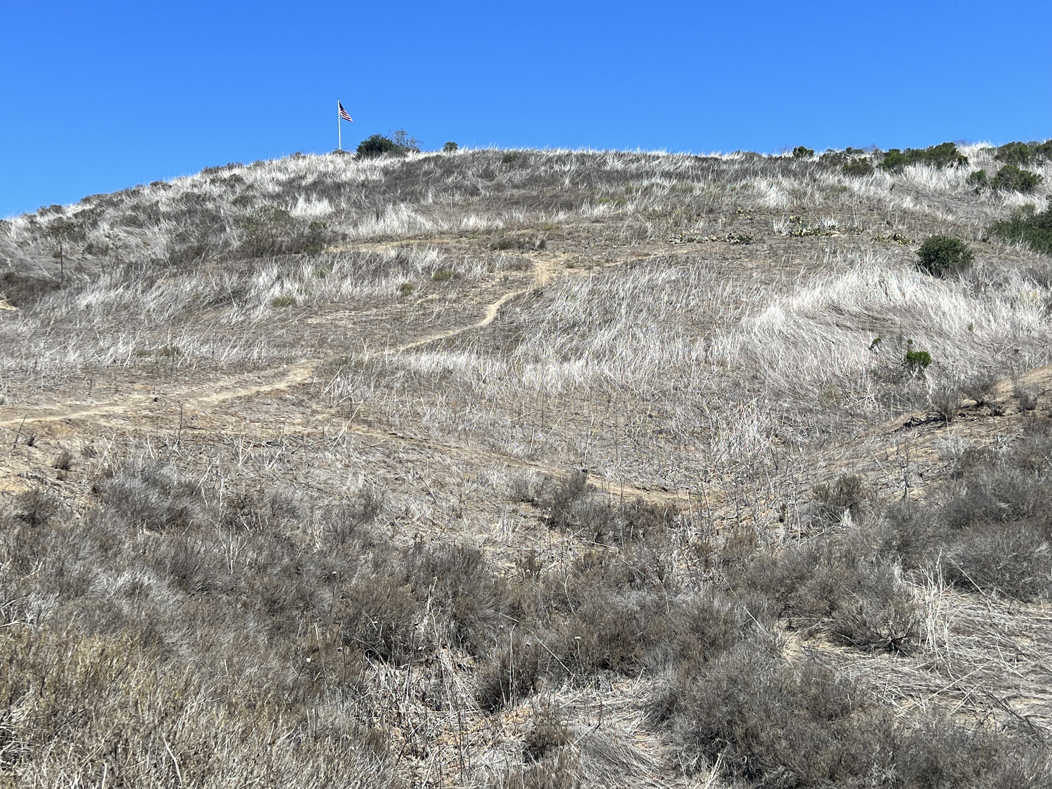
Clearly, this was Flagpole Hill.

Southern California Map.

Driving Map.
Parking coordinates: 33.48027°N, -117.6555°W.
Hiking Stats:
Hiking Map.
Summary
With coastal Southern Orange County not being well-known as a hotbed for hiking, there are still open spaces worthy of a visit. Flagpole Hill is one of them. I was able to form a loop hike out of it, which helped to add to it's appeal for video production.
Looking up the ridge, where the flag blows in the wind.
From a San Juan Capistrano neighborhood, I entered the open spaces and made a quick left to ascend toward Flagpole Hill. The summit has a tall flag pole on top, thus the name. It is so so known as Patrick's Hill.
On top of Flagpole Hill.
The summit is the hike high point, but the trail continues in a half circle along the ridge, where it crosses over a lower Hill before ending on a third high point, Peak 880.
Heading off on the ridge to visit the other high points.
I then dropped back to a five point junction where I return to the parking area through the Canyon. I combined this with a visit to Dana Point, where I was able to gather a handful of other easy hikes. 
A bench with a view on Peak 880.
Video:
Simulated Hike:

#159 Guatay Mountain

Looking up the side of the mountain. Southern California Map. Driving Map. Overall Hiking Totals: Hiking Map. Google Maps Trailhead Link Par...