 |
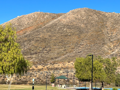
Dragon Peak from the park. |
 |
| Driving Map. |
 |
| Parking Map. |
Trailhead coordinates: 33.66482°N, -117.2487°W.
Summary
New Year's Day began the process of gathering as many hikes as I could possibly get to start the year off right. I started out early in Lake Elsinore. There were a handful of Inland Empire hikes that were completely new to me, so I felt a bit like an explorer by taking them on. From Canyon Hills Community Park, Dragon Peak stands directly overhead. It is possible to take a use trail straight up its side. However, I was looking for something a bit more comprehensive. I decided to skirt the edge of the park to create a loop hike of the peak.
Hiking Stats:
 |
| Hiking Map. |
New Year's Day began the process of gathering as many hikes as I could possibly get to start the year off right. I started out early in Lake Elsinore. There were a handful of Inland Empire hikes that were completely new to me, so I felt a bit like an explorer by taking them on. From Canyon Hills Community Park, Dragon Peak stands directly overhead. It is possible to take a use trail straight up its side. However, I was looking for something a bit more comprehensive. I decided to skirt the edge of the park to create a loop hike of the peak.
 |
| Passing through the oak woodland. |
I found a dirt biker trail that left the NW edge of the park and passed through a small canyon. Groves of oak trees at the edge of the park and behind the community of homes are quite impressive and also add to the scenic value of the hike.
Eventually, the trail bends back around and heads up the side of the ridge. This makes for a rather easy ascent of Dragon Peak. On the summit is a small cross. On the lower summit is the American flag. A little further down are painted rocks and a great view of the neighborhood.
 |
| Approaching the peak. |
 |
| On the summit. |
I once again avoided the use trail that went straight down. Instead, I opted to take a gradual trail that descended the eastern slope. This route also returned to Canyon Hills Park and the completion of a nice loop hike.
 |
| Neighborhood view from the painted rocks. |
Video:
Simulated Hike:


No comments:
Post a Comment