 |
Heading off toward the Hogbacks. |
 |
| Southern California Map. |
 |
| Driving Map. |
 |
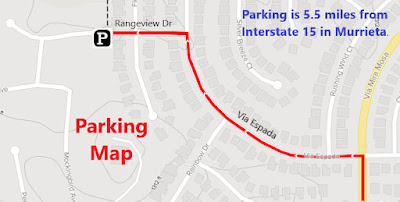
| Parking Map. |
Trailhead coordinates: 33.5856°N, -117.1536°W.
Summary
After going on a scouting mission on the La Alba Trail earlier, I was able to determine access to the Hogbacks was not best from the La Alba Trail. However, I could see that there was a good access point about a mile away. Instead of hiking it, I decided to drive to where it looked like the starting point would be. In that Murrieta neighborhood, I found a true easement between homes that marked the starting point of the access trail to the Murrieta Hogbacks.
Hiking Stats:
 |
| Hiking Map. |
After going on a scouting mission on the La Alba Trail earlier, I was able to determine access to the Hogbacks was not best from the La Alba Trail. However, I could see that there was a good access point about a mile away. Instead of hiking it, I decided to drive to where it looked like the starting point would be. In that Murrieta neighborhood, I found a true easement between homes that marked the starting point of the access trail to the Murrieta Hogbacks.
 |
| Approaching the Hogbacks. |
The easement leads to a trailhead board, which was blank of any notices. Beyond the board the trail drops to a creek and then crosses it. On the other side, it begins climbing gradually toward the Hogbacks. It pretty much goes in a straight line toward the ridge. Once on the ridge, an easy climb continues to the high point of the Murrieta Hogbacks. Great views all around, and no people on the hike. It really seemed like I was in a secret place, even though there were some homes nearby.
 |
| Nearing the summit. |
Once finding the true starting point, it was an easy hike out and back. I'm surprised that there really was no information about this hike anywhere that I searched. However, that's the benefit of actually getting out and exploring on your own. You never know, sometimes, what you will find.
 |
| On the summit. |
Video:Simulated Hike:


No comments:
Post a Comment