This blog will detail 1,000 video hikes in Southern California. By Southern California, I am drawing a line from San Luis Obispo to the Nevada Border. Anything south of that line will be declared "Southern California". In a way, it is a personal challenge to do so many hikes. Mainly, however, it is my way of showcasing how many hiking opportunities there really are right in our own geographic back yard. As a blog, it serves as a companion piece to my Youtube channel "1,000 Hikes in So Cal". It is also a work in progress, as I don't actually have 1,000 edited videos completed. This will take effort for quite some time before it is declared done. Even then, there will still be more out there. Here's to hiking and all the positive effects it has had on my life...and possibly yours!
Summary In the foothills of the San Gabriel Mountains sits a great oak tree grove. A trail system passes through the groves to form an enjoyable loop hike. Over the years, the starting point of the hike has changed. The proper starting point is now at the end of Stephens Ranch Road in La Verne.
The "Claw" tree points me in the right direction.
To begin the loop, I turned right at the start and descended into the canyon. The trail quickly drops into the shade of the oak groves. At the bottom of the canyon, the trail meets the Marshall Canyon Equestrian Center (where the trail used to begin from). The oak groves are dense and scenic all through this area. In the rainy season, wet creek crossings are the norm.
Leaving the oaks and heading to Claremont Hills.
The trail continues on Miller Ranch Road in a NE direction. It passes through the canyon with a gradual elevation gain. Eventually Miller Ranch Rd ends on the Claremont Hills Wilderness Park trail. I turned left and continued past the Claremont Hills Rest Station to reach Cobal Canyon Motorway.
Back into the canyon.
I turned left and began descending back into the canyon. Perspective and views are different than on the way up. Before long, it re-enters the oak groves leading back to the parking area and completing the loop hike of Marshall Canyon.
Many chances to enjoy the oak groves along the way.
Summary Whatever open spaces are preserved and trailed in suburban Orange Country are available for exploration. Some of these places charge fees, but there is no fee at El Modena Open Space. There is also a handful of hills to visit along the way. When starting at Encanto Pl., a signed starting point is the beginning of a loop through the hills. Bauer Benchmark is visited first. The trail climbs sharply nearly right off the bat, but it is a very short climb. The actual benchmark sits on top of what is the highest point of the hike.
Bauer Benchmark.
After leaving the high point, the hike naturally goes downhill from there. Along the way, there are two bumps of note. The first is Peak 686, which on my visit featured rocks placed into ground art. The next was Peak 620, which overlooked the neighborhood to the south. The trail bends back to Canon St, where the hike turns into an urban walk on the sidewalk. This is the least enjoyable part of the hike, but at least it parallels the hills along the way.
Peak 686.
A cone shaped peak sits on the other side of Canon St. This is Peak 800.
Peak 800.
When able to cross, I picked up a trail that gradually went up its side. When closer to the top, a summit use trail went the rest of the way. As expected, good views are had from the summit. From there, I returned to Canon St and wrapped up the loop by returning to the parking area.
Summary Calling this a hike is a bit of a stretch. However, when I came across a break in the rain in the middle of the day, I had to hit a trail. The hike up Rome Hill served this purpose nicely. Since the alternative is to just sit on the couch and be inactive, this was definitely a step in the right direction.
Approaching the top.
Within the Lakeland Village section of Lake Elsinore, Rome Hill sits between the town and the lake. A short dirt road leads from the end of Gregory Pl to the top of the hill. All this really is is a leg stretcher, since it is very short. The hike could be extended, however, by continuing down the other side and over to the lake. I found out later that Rome Hill can also be reached by extending the Lake Elsinore Levee Trail and capping off the hike by climbing up the side of Rome Hill. That would definitely be a grand turnaround point and much more rewarding hiking experience. That being said, however, this shorter hike simply cuts to the chase.
Looking north from the summit.
After taking in the view and avoiding rain from the black clouds overhead, I turned this into a succinct outing, while technically claiming a peak in the process.
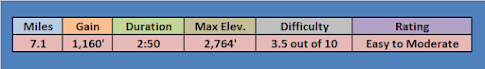
Summary The hike begins from a parking area on the south side of San Pasqual Valley Rd (Hwy 78). The trail immediately climbs out of the canyon toward the high points on the canyon walls. Not much shade along the way, but the climb is gradual. The pathway crosses near the high point of Peak 1755, however a short bit of light bushwhacking is needed to reach the top.
Peak 1755.
From there, I continued along the ridge to Peak 1635. Along the way, chairs are bolted into the ridge boulders to provide a "permanent" viewpoint.
A hikers lounge.
Peak 1635 sits at the end of the ridge. There are good views into the canyon, but more notably, this was the turnaround point.
Peak 1635 summit and register.
I retraced my steps back to a junction early into the hike. This time I took a left and went in a SW direction toward a different high point on the ridge. In about a mile, I reached Peak 1540.
Peak 1540 View.
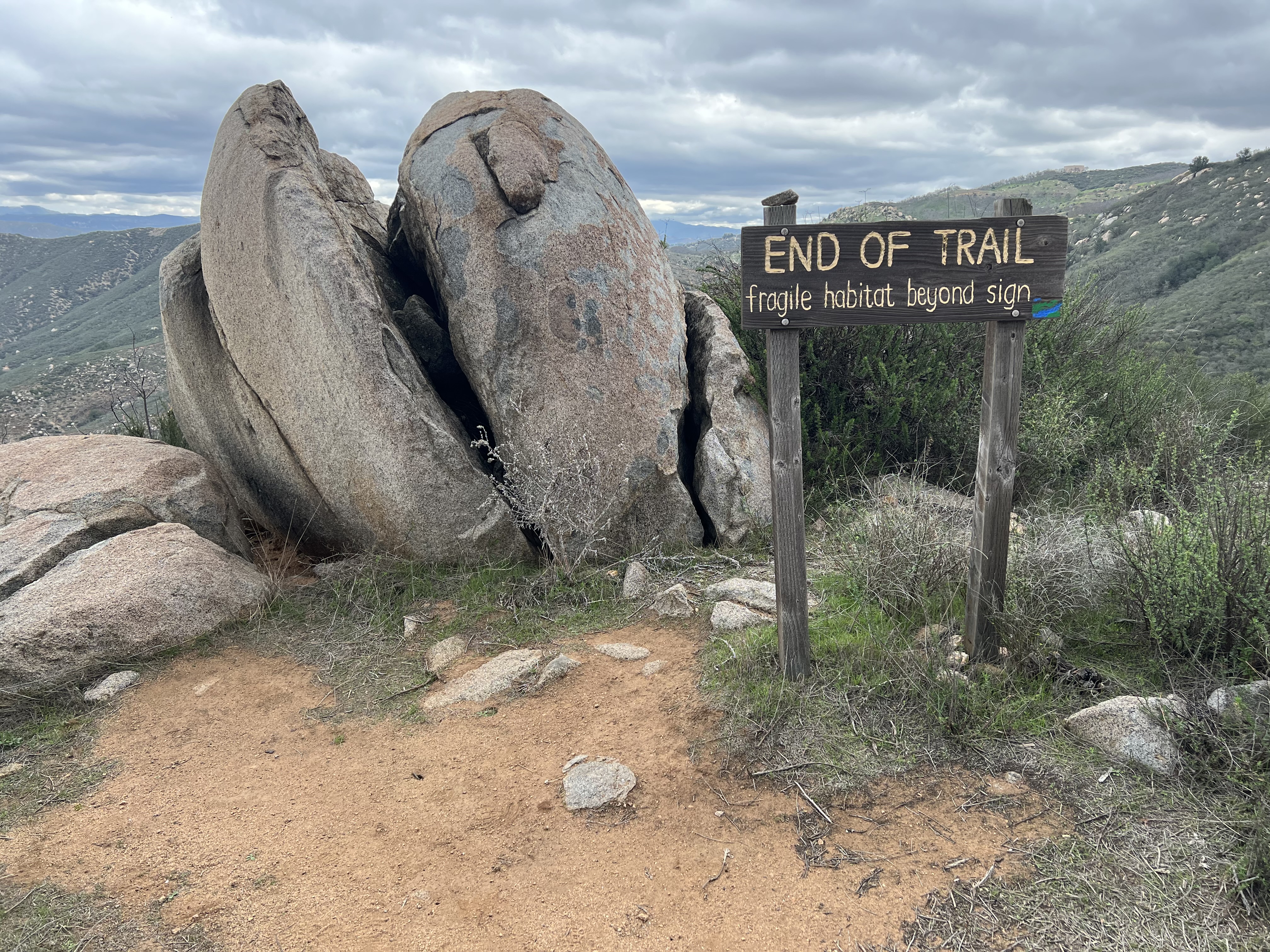
This Peak had even better canyon views and was worth the diversion off the main path. An "End of Trail" sign sits on the summit, making it clear that this was the absolute turn around point. From there, it is about a 2 mile gradual downhill hike back to the parking lot.
Summary The site is technically in the Inland Empire, but it seems to have its own identity. There is no graffiti and a lack of huge boulders along the hike, much like what is common in the Inland Empire. Since this is in a grape growing region, there are many vineyards and the soil color has more of a reddish hue. With an ample supply of wealthy land owners nearby, this sort of has an upper crust feel to it, sort of like the high class Inland Empire.
On the summit of Oak Mountain.
From my chosen parking spot next to a vineyard, I started hiking on the washed out dirt road. After crossing a zone where the road no longer exists, it begins climbing into the hills. After eventually leveling off, the trail splits. The right fork goes to Oak Mountain, while the left fork goes to the Black Hills High Point. Oak Mountain is reached with little difficulty. A benchmark sits on top which is labeled as "Henderson".
Henderson Benchmark.
The summit is long and flat, so who know what else I would find if I kept looking. After visiting, I headed back down and took a left on the trail I came in on. This led me to a prominent viewpoint overlooking the Temecula Valley) Peak 2640).
Peak 2640 at the end of the ridge.
While the road ended on Peak 2640, I doubled back to the first junction. This time I headed toward the Black Hills High Point.
Black Hills Highpoint.
The dirt road goes toward it and right over the top. There are twin high points, so I made sure to go to each one to make it official. I was rewarded with nice views from the high point. Heading back from there was easy and relaxing.