 |
| Stanley Peak comes into view. |
 |
| Southern California Map |
 |
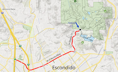
| Driving Map |
*Parking is 4.5 miles east of Interstate 15.
Trailhead coordinates: 33.16680°N, -117.05198°W.
Peakery Link: Stanley Peak, 1,985'
Summary:
To start the day, I headed to Escondido to a location that I had been to before, but one that I haven't been to in about 20 years, Daley Ranch. This would be the first hike that I would repeat by shooting it on video. Unlike my usual method of operation, I really didn't plan all week to be here, it just sort of fell into place when the new year rolled around.
The limited sized parking lot was jammed packed on my late morning arrival, but fortunately somebody was leaving. I grabbed the spot right away and began my day. This was my second chance to use my GoPro, which in retrospect worked out really well the second time around. I learned from my mistakes on the first outing and came out with much more workable footage. My goal for the day was Stanley Peak, and my plan was to just go out and back. However, since the trails that wind through Daley Ranch don't go in a straight line to the peak, it was up to me to make the right decisions at trail junctions in order to lead me there in the shortest route possible.
At one major intersection, I made a right turn instead of sticking to the main pathway. This pathway headed north, rather than in the eastern direction that the main trail was going. The peak was further to the north, so it seemed like a good option. However as I kept going, the trail started bending to the NW. Instead of bailing out and heading back, I opted to find another intersecting pathway. Eventually I did, by picking up the Sage Trail. Luckily for me this trail gave me a sampling of the better qualities of the ranch. It passed ranch ponds, historic ranch buildings, and Engelman oak groves. This allowed me to use both my GoPro and cell phone camera at multiple times during the hike.
After a visit to the historic ranch structures, the trail aimed east and in the direction of Stanley Peak. After passing a second pond, the Sage Trail intersected the Stanley Peak Trail. I followed this trail to reach the summit. As always, I soaked in the ambiance of the mountain top for a short piece of time before heading right back down again. This time, I continued south on the Sage Trail, where I eventually formed a loop through the park. Upon my return to the full parking lot, it was my turn to grant a parking spot to another trail seeker looking for a place to park. The cycle of Daley Ranch visitor went full circle with the passing of the "parking guard" once my spot was claimed. This was a great hike to start the year off with, good thing I planned to do it all along...or not!
 |
| On the summit of Stanley Peak. Video: Simulated Hike: |


No comments:
Post a Comment