This blog will detail 1,000 video hikes in Southern California. By Southern California, I am drawing a line from San Luis Obispo to the Nevada Border. Anything south of that line will be declared "Southern California". In a way, it is a personal challenge to do so many hikes. Mainly, however, it is my way of showcasing how many hiking opportunities there really are right in our own geographic back yard. As a blog, it serves as a companion piece to my Youtube channel "1,000 Hikes in So Cal". It is also a work in progress, as I don't actually have 1,000 edited videos completed. This will take effort for quite some time before it is declared done. Even then, there will still be more out there. Here's to hiking and all the positive effects it has had on my life...and possibly yours!
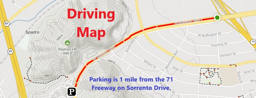
In South-East Pomona, there are a number of hills bordering neighborhoods. The Eagle Scout Trail passes through some of these hills. The hike begins along the busy Mission Blvd. I parked on Sorento Drive and found a safe crossing point of Mission Blvd to reach the start of the trail. A locked vehicle gate is the starting point. The trail begins by following the road into the hills. It gradually climbs toward the high points. The highest Peak, Peak 1381 offers good views over the San Gabriel Valley to the west and the Inland Empire to the east.
"Colorful" boulders overlook the Inland Empire.
Peak 1381 is a good turnaround point, but there was more open space to the east along the ridge. I continued on the ridge to a lower high point overlooking the Inland Empire. This lower point was a much better turnaround point. However, despite being heavily tagged with graffiti, the views are well worth the time and effort.
Looking back up the ridge.
From there, I climbed back up to Peak 1381, then continued straight up the next hill (while bypassing the road I came in on). On this hill, there is a bench and good views into Pomona. A single track use trail continues down the slope and eventually reaches the starting point of the hike along Mission Blvd.
The Eagle Scout project.
I wound up doing this hike twice on successive weekends due to a video equipment malfunction. This was my one and only time trying to sync my GoPro with an app on my phone. I managed to make it work, but somehow I pressed a button and the GoPro clips became fast motion. Naturally, this completely ruined the video experience and required a revisit before posting to YouTube. Good thing it was on a trail that was only 10 minutes away from home!


No comments:
Post a Comment