This blog will detail 1,000 video hikes in Southern California. By Southern California, I am drawing a line from San Luis Obispo to the Nevada Border. Anything south of that line will be declared "Southern California". In a way, it is a personal challenge to do so many hikes. Mainly, however, it is my way of showcasing how many hiking opportunities there really are right in our own geographic back yard. As a blog, it serves as a companion piece to my Youtube channel "1,000 Hikes in So Cal". It is also a work in progress, as I don't actually have 1,000 edited videos completed. This will take effort for quite some time before it is declared done. Even then, there will still be more out there. Here's to hiking and all the positive effects it has had on my life...and possibly yours!
By the time I reached this day, I felt like a lion confined in a cage. I had limited myself to easy hikes essentially since the beginning of the year. Truly, there was low hanging fruit as I intended to get all the local easy hikes documented on video. Meanwhile, I wanted to do something a little more challenging. Recently, I noticed local San Gabriel Mountain peaks that I had not yet visited appear on the Peakery database. I was determined to get them added to my completed list, so off I went when the weekend hit.
Transplanted Castro Peak Fire Lookout.
The hike begins in Eaton Canyon. Instead of beginning at the overcrowded Eaton Canyon Trailhead, there is a closer starting point in an Altadena neighborhood at the Mt Wilson / Pinecrest Gate. From there, the roadway crosses Eaton Canyon and then climbs the old Mt Wilson Toll Road toward Henninger Flats. There is nearly no shade at all on the approach to Henninger Flats. While there, I took a look at the old Castro Peak Fire Lookout, which sits on display there. The museum was closed this time around, but that was OK, I was only about half way to my daily goal.
Hiking up the road.
The road continues past the shady Henninger Flats and higher into the range. At about 5.5 miles into the hike, the hike meets a use trail that rises up the slope to the south of the roadway. It leads to a good viewpoint over the San Gabriel Valley. This was the summit of Mt Fuji.
Mt Fuji summit & Mt Princeton in the background.
Not sure if this was named because it was the peak that Godzilla looked over before sacking Los Angeles in an old movie. This gave me something to contemplate as I continued to Mt Princeton.
Approaching Mt Princeton.
About a mile beyond, the road meets a saddle between Mt Princeton and Mt Yale. I had been at this spot before when doing the Mt Yale hike, except I had arrived from the NE instead of the SW as I did this time. I took a right turn and went up a firebreak to the summit of Mt Princeton. From the summit there are good valley views and of the rest of the range.
On the summit overlooking the San Gabriel Valley.
This was my true turnaround point. Since I didn't use a good tracking app, I'm not positive of the mileage to get there, It was somewhere between 6.5 to 7.5 miles. So by heading back down, I doubled my mileage back to Pinecrest Gate. More front range peaks in the San Gabriel's get checked off!
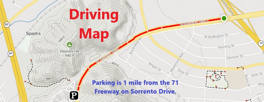
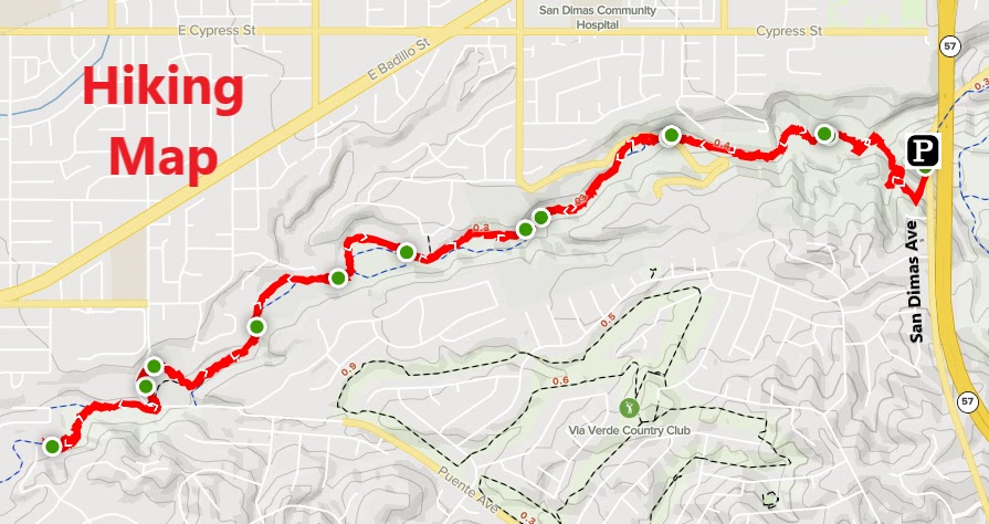
In South-East Pomona, there are a number of hills bordering neighborhoods. The Eagle Scout Trail passes through some of these hills. The hike begins along the busy Mission Blvd. I parked on Sorento Drive and found a safe crossing point of Mission Blvd to reach the start of the trail. A locked vehicle gate is the starting point. The trail begins by following the road into the hills. It gradually climbs toward the high points. The highest Peak, Peak 1381 offers good views over the San Gabriel Valley to the west and the Inland Empire to the east.
"Colorful" boulders overlook the Inland Empire.
Peak 1381 is a good turnaround point, but there was more open space to the east along the ridge. I continued on the ridge to a lower high point overlooking the Inland Empire. This lower point was a much better turnaround point. However, despite being heavily tagged with graffiti, the views are well worth the time and effort.
Looking back up the ridge.
From there, I climbed back up to Peak 1381, then continued straight up the next hill (while bypassing the road I came in on). On this hill, there is a bench and good views into Pomona. A single track use trail continues down the slope and eventually reaches the starting point of the hike along Mission Blvd.
The Eagle Scout project.
I wound up doing this hike twice on successive weekends due to a video equipment malfunction. This was my one and only time trying to sync my GoPro with an app on my phone. I managed to make it work, but somehow I pressed a button and the GoPro clips became fast motion. Naturally, this completely ruined the video experience and required a revisit before posting to YouTube. Good thing it was on a trail that was only 10 minutes away from home!
The Michael D. Antonovich Trail in Covina is actually a unique trail in Southern California. Unique in the sense that the trail is about 90% shaded. There are other shaded trails, but not as consistent as this one is. The trailhead is at an overlook above the canyon. It is noisy and busy since it is right next to the freeway and parking is limited. The trail descends into the canyon along a stretch that is entirely without shade, but that changes on a dime.
A scenic creek crossing.
Once in the canyon, the trail descends along a creek underneath heavy shade. Along the way there are several creek crossings, but not as big as the first one. Many visitors often turn around here and miss out on the rest of the hike. A well chosen rock hop can get you across, but either way, it is worth the risk of getting your feet wet in order to explore the canyon.
A shaded canyon experience.
The trail continues on the floor of the canyon in the small canyon bordered by various neighborhoods. In the fairly recent past, this area served as a dumping ground for unwanted appliances, tires, graffiti, or simply trash. However, in recent years, this has been cleaned up, making this a must visit hike for So Cal hikers.
One of many creek crossings.
Within the canyon, there are other access points to park in order to begin at different starting points. Because of that, the trail passes through these parking lots to continue through the canyon. This cuts into the solitude a bit, but the separation from the ongoing scenery is only temporary. The hike essentially ends at a red building across from the flowing creek. Naturally, it is possible to continue through the canyon by walking in the creek. However, this makes a great turnaround point while maintaining dry shoes. Heading back allows you to enjoy the scenery all over again, and while actually missing the direct sunlight (maybe just a little bit) along the way.
Some of the best hiking in Chino Hills State Park is outside of the popular areas. Another benefit is that there are no fees in these outlying areas. Not only do you get to keep your money, but there is also solitude. To start the hike, I parked in the Green River Golf Club parking lot. I'm not sure if they still allow non-customer parking, otherwise, parking would be further down the road. From the parking lot, I left the golf course and crossed the railroad tracks. Beyond the tracks, a dirt road passes through a state park gate to officially enter Chino Hills State Park.
Scully Hill summit register.
The state park road climbs gradually, allowing for good views of the surrounding community and the 91 freeway. Further up, Scully Hill looms on the edge of the ridge. The road heads in its direction and passes right along its side. A trail breaks off to the left on its lower slopes, and I utilized it to reach the summit. As usual, there is no better place to appreciate the views than from the summit. Ordinarily, this would be the turnaround point, but I really wanted to do a loop hike of the eastern portion of Chino Hills State Park. So I went back out on the trail and continued west.
Looking west toward Peak 1155.
The trail was not overgrown and easy to follow as it went up and down through the hills. The next targeted peak was about 2 miles away on the Scully Ridge Trail. This was Peak 1155. After a gradual climb, a metal pole sticks out of the top of the peak. It's a peaceful spot where I paused for a few minutes.
The summit of Peak 1155.
From the peak, I continued west until reaching the next trail junction. I turned right there and descended to Lower Aliso Canyon. A right turn on Lower Aliso Canyon created the looping portion of the hike, as it lead back toward Green River Golf Club. Green hills and flowers starting to bloom made for a memorable experience.
Summary The hike starts at Glendora Centennial Heritage Park. From the sign, I proceeded along a fence line and stepped into history. There sits a depicted 19th to 20th century citrus ranch. Included is a historic home, various small buildings, numerous smudge pots, and all kinds of period piece parts and supplies. It appears to be a site better suited for tours, but it makes a great visual start to the hike. The trail continues past the historic area and eventually connects with Elwood Avenue. A right turn connects with a trail that returns into the small pocket of wilderness in Glendora. The area traversed on the hike passes through and over hills in an area known as South Hills Wilderness.
Peak 1212.
The trail going in is a wide dirt road with some shade (Alosta Canyon Trail). Instead of following the dirt road all the way in (which is still a good option), I picked up a single track trail that quickly goes up slope (South Fork Trail). The climb is steep but very quick.
The summit of Peak 1212.
The trail meets another dirt road on the ridge (South Hills Trail). On the other side of the road, a use trail continues to the top of the highest peak in the wilderness (Peak 1212). Great city views spill out below. I picked up the continuation of the trail off the other side, which eventually met up with the South Hills Trail further down the ridge.
Summit benchmark.
While on the ridge, the hike continues in a flat and easy route toward the far edge of the hills to the west. At the western edge, The Walnut Trail passes next to a reservoir and begins descending back toward the parking lot. This is a scenic walk through a walnut grove and through some small canyons. Some other trail branch off from the Walnut Trail which offers some more variety. Though, to complete a loop of the area, I continued on to the parking lot, while wrapping up a nice wilderness hike within the city limits.


