This blog will detail 1,000 video hikes in Southern California. By Southern California, I am drawing a line from San Luis Obispo to the Nevada Border. Anything south of that line will be declared "Southern California". In a way, it is a personal challenge to do so many hikes. Mainly, however, it is my way of showcasing how many hiking opportunities there really are right in our own geographic back yard. As a blog, it serves as a companion piece to my Youtube channel "1,000 Hikes in So Cal". It is also a work in progress, as I don't actually have 1,000 edited videos completed. This will take effort for quite some time before it is declared done. Even then, there will still be more out there. Here's to hiking and all the positive effects it has had on my life...and possibly yours!
Several peaks tower over the city of Banning. One in particular (Barker Peak) is reachable after a drive up Highway 243. To reach the hiking starting point, I drove 8 miles south of Interstate 10 to Twin Pines Road. From there it is a short drive to Valley Hi Drive on the left. The road may not be signed, but it is a dirt road passing through ranch properties toward Barker Peak. To reach the hiking starting point, it is best to find a place to park as the road gets rough.
Hiking up the road.
The dirt road starts heading uphill. There is one wide bend in the road, creating a bit of a switchback. It is pretty much a straight shot from there. On top is the cement foundation of a former lookout tower. Great views below, which is the true hallmark of a good lookout site. As a recommendation, pairing this hike with nearby Ranger Peak will knock off two mountain conquests within a few hours.
I was originally looking to hike Lookout Mountain and Table Mountain on the same hike. However, since my day started late, I cut out Table Mountain, since it would have taken more time than my backup plan, which was Asbestos Mountain.
Approaching the summit block.
After completing one HPS summit on the day, I accepted the challenge of doing two of them. The start of the hike to Asbestos Mountain begins after driving a series of residential dirt roads in the community of Pinyon Pines. I parked in front of the last house at the end of the road, and started hiking on a jeep road leading toward Asbestos Mountain. When the road started bending away from the peak, I left the road and went cross country toward a gully. When reaching the gully, I found trail cairns which mark the route to the peak.
On the summit.
Without the rock cairns, the climb would be rather difficult, so I found them to be helpful, though often difficult to spot. The climb up the gully is a rock scramble for the most part. Time was starting to run out on me, though, so I had thoughts of bailing out and coming back another day. To complicate matters, I lost the rock cairns about 3/4 of the way up, and wound up doing a much more difficult rock scramble. Before reaching the summit, I again found the rock cairned route. The sun was getting close to dipping behind the nearby Desert Divide, so I quickly followed the cairns to the peak.
Summit views.
The summit is not a simple walk to summit. I had to climb some class 3 boulders before reaching the summit high point. I stayed for about 2 minutes, where I shot a short video and took in the views. I then immediately climbed down the boulders and stuck close to the rock cairns. I was determined to not get caught in the gully when it got dark, so I wanted to get back down as soon as possible. Fortunately, navigation was much easier going downhill, where I found myself on the desert floor and back at my parking spot at about 5 minutes before it got dark. Mission accomplished!
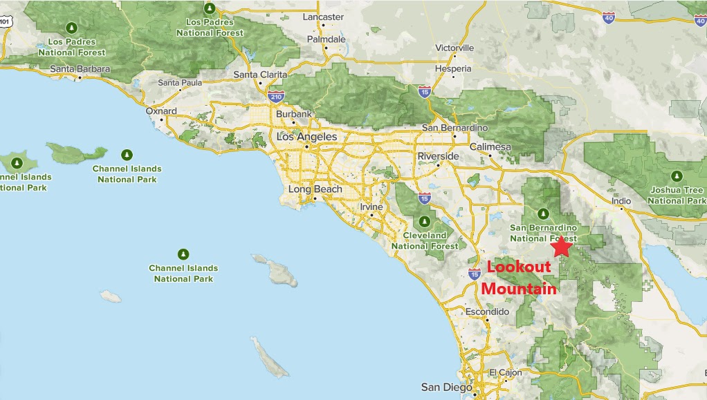
Near the intersection of Highway 371 and Highway 74 east of Anza, the Pacific Crest Trail crosses Highway 74. From the parking area, I headed south on the PCT. Lookout Mountain is visible from the highway, but it is on private property. In order to gain access to the peak, I needed to get there in a round about way. By going 1.5 miles south on the PCT, it takes me south of the private property line. A use trail leaves the PCT in a gully. The trail is well marked with rock cairns on a rather steep climb toward the top of the mountain.
Approaching the summit.
With relatively little shade up the peak, I benefitted with the cool January weather. Once reaching the summit, I found the usual red coffee can register that I usually find on HPS peaks (HPS = Hundred Peak Section, which is a list of 280+ peaks on a prestigious Southern California peak challenge list). Right behind the summit is a security fence marking the private property line. I enjoyed my short visit and returned the way I came. I'll return to this section of the PCT again when I choose to do the Table Mountain hike, which is about 4 miles south of Lookout Mountain. This means I shall return someday, which is always a good thing!
After spending so much time lately chasing easy to moderate nearby summits, I felt the need to take advantage of the cool weather and get a more strenuous peak. I had been in the Ramona area in the summer and experienced the heat. I wanted to get the tougher Mt Gower hike completed on a cool day rather than in the hot summer months. January seemed like a reasonable time to swing by, so I made it a priority.
A rare moment of shade trees on the trail.
I arrived relatively early, but parked at the end of the road, rather than driving in on the gravel access road. This added about a half mile to my hiking day. Once at the trailhead, the trail wasn't very clear to me, because the ones I saw didn't go in the direction of the peak. I eventually had to take a chance before realizing that I was indeed going in the right way. The trail bends around in odd angles, and sometimes goes downhill and away from the peak. However, what it is doing is to go around some of the lower ridges before elevating on the ridge for Mt Gower. In short. it gets where it is going in a round about way.
A good view of Mount Gower early in the hike.
As expected, there is not much shade on the hike, thus the January visit. When there were pockets of shade, it was a welcomed relief, even in January. Meanwhile, the trail climbs toward granite slabs below the summit. The hardest part of the hike begins here, with narrow use trails climbing through the rocky slabs. I arrived at the summit boulder and declared victory. I noticed a trail that continues along the ridge to the east, but ignored it, since it didn't look any higher than where I was. I returned along the same pathway to conclude the day hike and feeling satisfied about knocking off another major San Diego summit.
Approaching the summit.
Unfortunately, after doing research, I realized that the true summit is on that trail to the east. I still consider that I completed the peak though, since it looks like an optical illusion to call the eastern peak the high point, and it was a short flat walk away.
The Denk Mountain Trailhead is in a residential neighborhood, which turned out to be an easement between properties. Beyond the pavement, it becomes a trail. A right turn led to a mostly non-utilized trailhead kiosk. I turned left at the kiosk and followed the trail toward the peak. Two separate trails have been worn down through the years. One is a gradual trail with switchbacks, and the other goes straight up. Since it is not a long climb, I just went straight up. The summit is wide and has nice views. On the way down, I started out on the gradual descent, but found it unnecessary right away. When I had access to the express route, I grabbed it and followed it back down to my car.
To start the day, I headed to Escondido to a location that I had been to before, but one that I haven't been to in about 20 years, Daley Ranch. This would be the first hike that I would repeat by shooting it on video. Unlike my usual method of operation, I really didn't plan all week to be here, it just sort of fell into place when the new year rolled around.
A scenic ranch pond.
The limited sized parking lot was jammed packed on my late morning arrival, but fortunately somebody was leaving. I grabbed the spot right away and began my day. This was my second chance to use my GoPro, which in retrospect worked out really well the second time around. I learned from my mistakes on the first outing and came out with much more workable footage. My goal for the day was Stanley Peak, and my plan was to just go out and back. However, since the trails that wind through Daley Ranch don't go in a straight line to the peak, it was up to me to make the right decisions at trail junctions in order to lead me there in the shortest route possible.
Historic barn in Daley Ranch.
At one major intersection, I made a right turn instead of sticking to the main pathway. This pathway headed north, rather than in the eastern direction that the main trail was going. The peak was further to the north, so it seemed like a good option. However as I kept going, the trail started bending to the NW. Instead of bailing out and heading back, I opted to find another intersecting pathway. Eventually I did, by picking up the Sage Trail. Luckily for me this trail gave me a sampling of the better qualities of the ranch. It passed ranch ponds, historic ranch buildings, and Engelman oak groves. This allowed me to use both my GoPro and cell phone camera at multiple times during the hike.
Approaching Stanley Peak.
After a visit to the historic ranch structures, the trail aimed east and in the direction of Stanley Peak. After passing a second pond, the Sage Trail intersected the Stanley Peak Trail. I followed this trail to reach the summit. As always, I soaked in the ambiance of the mountain top for a short piece of time before heading right back down again. This time, I continued south on the Sage Trail, where I eventually formed a loop through the park. Upon my return to the full parking lot, it was my turn to grant a parking spot to another trail seeker looking for a place to park. The cycle of Daley Ranch visitor went full circle with the passing of the "parking guard" once my spot was claimed. This was a great hike to start the year off with, good thing I planned to do it all along...or not!