 |
| Looking up the ridge from the parking area. |
 |
| Southern California Map |
 |
| San Diego Area Map. |
 |
| Driving Map. |
 |
| Parking Map. |
Parking coordinates: 32.83496°N, -116.73196°W.
Summary
There is an established trailhead and an alternate trail to Viejas Mountain. Somehow I wound up at the alternate trail and didn't realize it until I was heading up the ridge. By then, it didn't make sense to turn back but to continue on. Fortunately, the trail is clear enough heading up the ridge where bushwhacking really wasn't necessary. It is unshaded and steep in sections, so attempting on a cool day would be a better call.
Hiking Stats:
 |
| Hiking Map. |
There is an established trailhead and an alternate trail to Viejas Mountain. Somehow I wound up at the alternate trail and didn't realize it until I was heading up the ridge. By then, it didn't make sense to turn back but to continue on. Fortunately, the trail is clear enough heading up the ridge where bushwhacking really wasn't necessary. It is unshaded and steep in sections, so attempting on a cool day would be a better call.
 |
| Approaching Viejas Mountain. |
Elevation gain tends to level out a bit when getting higher on the ridge. Along the way, it crosses over a few false summits before the true high point appears. Before reaching it, the hike intersects the true Viejas Mountain Trail coming from the west. That was the first time I witnessed any other hikers on the day.
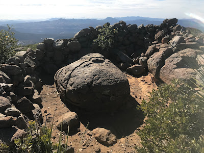
Once reaching the summit, it has a nice rocky windbreak and a summit benchmark. Nice vistas captured my attention while on top. It was easier going down, plus the route was more clearly visible while descending, where I wrapped it up at the parking area alongside Interstate 8.
 |
| On the summit. |
 |
| Summit benchmark. |
Video:Simulated Hike:


No comments:
Post a Comment