 |
Approaching Sitton Peak. |
 |
| Southern California Map. |
 |
| Driving Map. |
 |
| Parking Map. |
Trailhead coordinates: 33.61236°N, -117.42652°W.
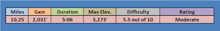
Hiking Stats:
On the way back to Five Points, I picked up the North Tenaja Trail to see if I could visit another nearby peak of Bear Ridge, Unfortunately, this side trek proved to be unsuccessful since I could not find any access trail and was unwilling to bushwhack.
When I was ready to give up, I simply returned to Five Points. Still up for a little variety, I took the alternative Bear Ridge Trail. This trail goes parallel to Bear Canyon, but is mostly on the ridge above Bear Canyon. It later reconnects with the Bear Canyon Trail before returning to the parking lot at Ortega Oaks.
Video:
Simulated Hike:
 |
| Hiking Map |
Summary
I find myself drawn to this part of the Santa Ana Mountains in the fall. Sitton Peak is a hike that I had intended to revisit at some point, and it became obvious that today was the day. I accessed the Bear Canyon Trail and passed through the scenic canyon. At Five Points Junction, it is a sharp right to access the Sitton Peak Trail. The wide trail continues toward Sitton Peak.
 |
| On the summit. |
The retired dirt road provides a wide thoroughfare for hiking. It winds up going through the hills before leading to a summit access trail. The narrow access trail is steep and rather unforgiving on up to the peak. The summit had a few summit signs, a register, and great views.
 |
| Summit benchmark. |
I returned the same way to Five Points. At just past the junction, I ascended the slope to the right on a use trail to reach Boy Scout Peak. It is a wide summit, so views really aren't very memorable from the high point.
 |
| On top of Boy Scout Peak. |
 |
| Descending back to Five Points. |
 |
| Looking back at Boy Scout Peak. |
Simulated Hike:


No comments:
Post a Comment