 |
| North Van Dam Peak. |

 |
| Southern California Map. |
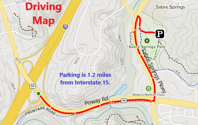 |
| Driving Map. |
Parking coordinates: 32.951572°N, -117.09581°W.
Summary
There are three trailheads around the Van Dam Peak area that offer alternative starting points. The one I chose left from Sabre Springs Park. The starting point isn't very clear. I had to walk around the side of a baseball field and find a use path that goes up the embankment. Once above the park by a few yards of elevation, trails cut across the open spaces. I took a left and followed the trail going up the ridge.
Hiking Stats:
 |
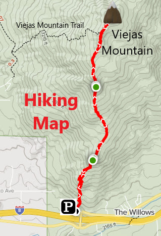
| Hiking Map. |
There are three trailheads around the Van Dam Peak area that offer alternative starting points. The one I chose left from Sabre Springs Park. The starting point isn't very clear. I had to walk around the side of a baseball field and find a use path that goes up the embankment. Once above the park by a few yards of elevation, trails cut across the open spaces. I took a left and followed the trail going up the ridge.
 |
| North Van Dam summit. |
A few high points are visible from the park. The highest is North Van Dam Peak. I made North Van Dam Peak my target as I worked my way along the ridge and right up to it. The trail crosses right over the top where I found a well tagged building foundation on the summit. My true target of the hike was Van Dam Peak. I made North Van Dam Peak my turnaround point and worked my way back to a trail junction. Instead of blowing past it this time, I took a left turn on it and proceeded on one of the different trails on the ridge. After about 100 yards or so, I found a break in the fence that was lining the path. This was my secret front door entrance to Van Dam Peak.
 |
| Van Dam Peak. |
Although it looked totally overgrown on the way to Van Dam Peak, a use trail actually snaked its way through the thick overgrowth and on up to Van Dam Peak. All doubts were allayed as I reached the summit and found a red coffee can register just sitting there. There were limited views from the top due to the bushes and trees crowning the summit. It was a nice quiet and remote spot to hang around on for a little while. When going back, I made a wrong turn and started heading down the wrong trail at first. I corrected that eventually before working my way back to the way I came in from Sabre Springs Park. I seem to building a good track record of good late afternoon hikes in San Diego!
 |
| On the summit of Van Dam Peak. |
Video:Simulated Hike:


.JPG)


