 |
| Mt Harvard & Harvard Ridge. |
 |
| Southern California Map |
 |
| Driving Map |
Parking coordinates: 34.22502°N, -118.06450°W.
Hiking Stats:
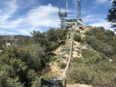
The trail continues forward to Mt Harvard from there. It is slow going and steep in parts, but along the way, the trail meets man made structures associated with the summit tower facility. This is a way of letting you know that you are close to the top. Eventually, the trail rises to the summit which has a large building to go with the towers.
The trail connects with the summit road that drops to the gate that was seen earlier in the hike. At first it seems like you are locked in, however, there is no side fence, so you simply swing around the side of the gate and you are back on Mt Wilson Toll Road.
It is about a 1 mile climb from there back to the parking area near the Mt Wilson entrance gate.
Video:Simulated Hike:
 |
| Hiking Map |
Summary
From the Mt Wilson entrance gate, Mt Wilson Toll Road is accessed. This old paved road descends to an entrance gate to Mt Harvard, adjacent to the single track Mt Wilson summit trail. Go left before reaching the gate and continue on the road. This bypasses Mount Harvard and leaves it for later in the hike. The paved road is no longer a thing at this point, so the hike remains on the rocky dirt road. The hike passes and ignores the Winter Creek Trail on the way down. Shortly past this junction, Mt Yale comes in view. In about 3 miles, the road arrives at Harvard Saddle, which is in between Mt Yale and Mt Princeton. A right turn begins ascending Harvard Ridge toward Mt Yale.
 |
| Approaching Mt Yale. |
The use trail gets overgrown, but using the high point ahead as your target is the way to do it when in doubt. The trail eventually tops out on the summit of Mt Yale, which has a benchmark.
 |
| Mt Yale Benchmark. |
 |
| Approaching the summit of Mt Harvard. |
 |
| On the summit of Mt Harvard. |
 |
| Heading back to Mt Wilson. |


No comments:
Post a Comment