This blog will detail 1,000 video hikes in Southern California. By Southern California, I am drawing a line from San Luis Obispo to the Nevada Border. Anything south of that line will be declared "Southern California". In a way, it is a personal challenge to do so many hikes. Mainly, however, it is my way of showcasing how many hiking opportunities there really are right in our own geographic back yard. As a blog, it serves as a companion piece to my Youtube channel "1,000 Hikes in So Cal". It is also a work in progress, as I don't actually have 1,000 edited videos completed. This will take effort for quite some time before it is declared done. Even then, there will still be more out there. Here's to hiking and all the positive effects it has had on my life...and possibly yours!
The hike to McKinley Mountain is short but steep. However, finding the starting point might be the toughest part. There are no signs or established trailheads. Instead, I studied Google Maps and was observant when passing through on the highway over the years. On those instances, I concentrated on looking for a starting point while I was heading somewhere else. Finally, with enough research, I felt confident to park in a wide pullout southeast of the peak along Highway 330. I tucked my car as close to the edge of the pullout as I could so that I would not be a problem for cars pulling over. As it turned out, I was the only car there during my visit. I knew this since I had a clear view of the pullout for much of my peak hike.
Admiring the progress made while climbing.
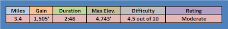
After feeling secure with my parking spot, I headed up the slope on a use trail that led up the steep slope and through the brush. The initial climb was roughly a 500 foot gain in just a quarter mile. My calves were on fire by the time I reached the ridge. Once on the ridge, it looked like a straight shot toward the peak, but in a steep trajectory. Despite the clarity, I found myself stopping every so often to give myself a break on the steep climb.
On the first false summit looking at the second one.
When I saw my first poppy for the year, that gave me another excuse to stop and take it easy for a few moments. Once reaching a false summit (the first of two), I took the time to unstrap my GoPro so that I could stage a shot of me hiking along the trail. This is a technique that I see often on YouTube by other contributors, so I though I would try it out. I was actually kind of pleased with the outcome, but I never tried it again. I figured right away that my videos were about the hikes, not about me.
On the summit.
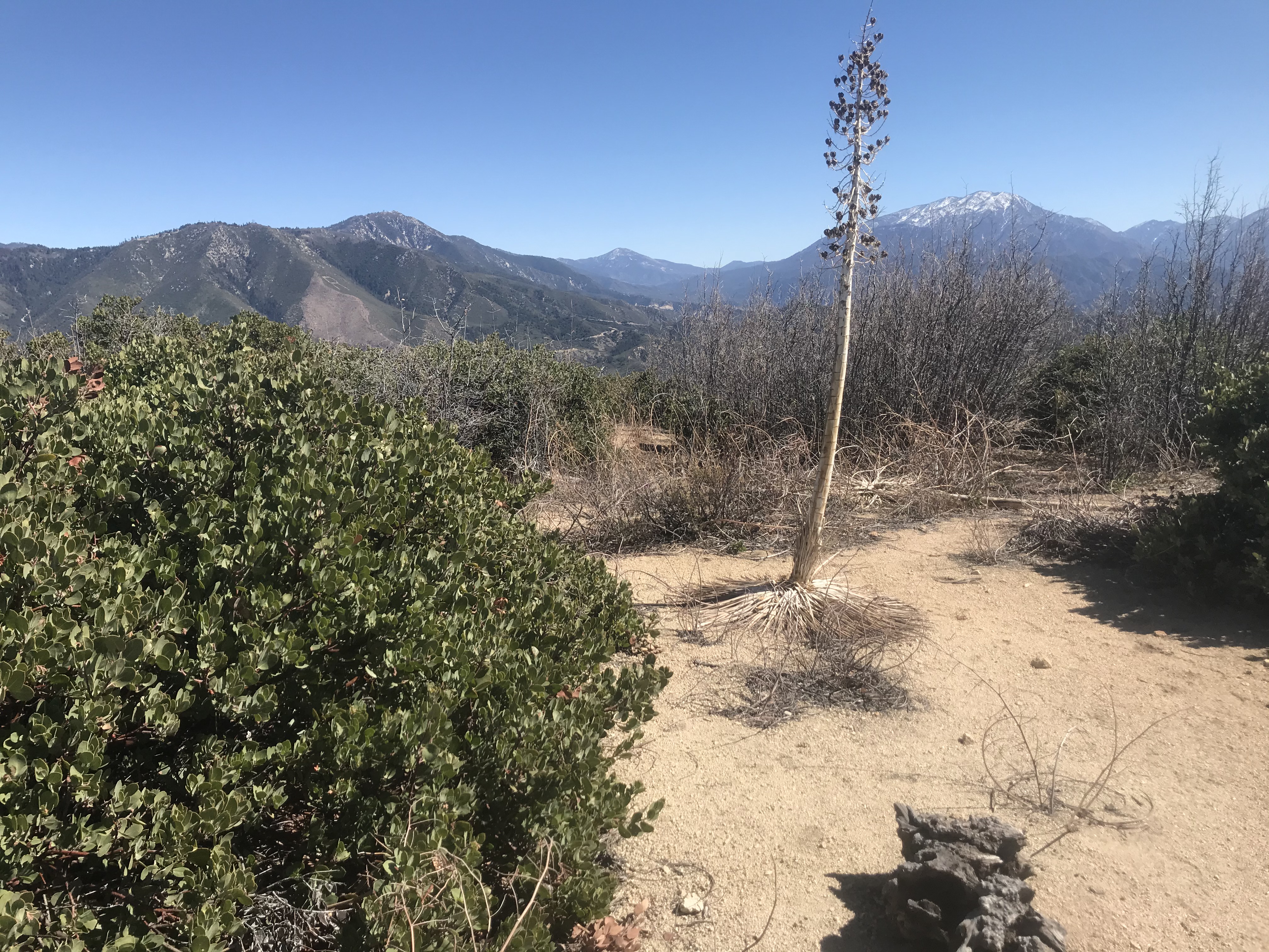
Once reaching the second false summit, the top of the mountain was in view on the ridge. Along with the view was a bit of excitement, since I had been plotting to visit here for years. Even on the previous weekend, when I was atop Harrison Mountain, I remember trying to solve the McKinley Mountain "puzzle" while on the descent. Meanwhile, once reaching the top of McKinley, I shot a short video where I re-created reaching the top (despite trying to be serious, this turned out to be one of my more comedic moments on video). Meanwhile, like all other mountain visits, it ended with a long descent back to the parking area. I was proud of the completion of this climb, and I was looking forward to sharing it. As I often say: Mission accomplished!
Finding the trailhead is rather straightforward. I drove Highway 330 to a large pullout at the intersection with Old City Creek Road. From there, the hike began by walking down the dirt Old City Creek Road. After walking for about a tenth of a mile, I veered off the road on a use trail that went in the direction of Harrison Mountain. Beyond that point, I kept expecting the trail to disappear somewhere on the lower slopes, but the defined pathway kept going. The trail gains the ridge and passes through some overgrown sections before reaching a steep climbing section that tops out at the summit. There are some tremendous views up there, made that much more enjoyable by visiting on a cool and comfortable day. I signed the register and continued shooting video on the way down. The visit here turned out to be one of my better video efforts early in the year.
On the summit.
On the way down, I took some time overlooking McKinley Mountain, which is across the highway from Harrison Mountain. McKinley was climbed a week later, since it was seared in my brain on the way down. I found descending the mountain to be more difficult than climbing it, since there are some barren slopes with loose rock.
Summit register.
Also, at the base of the mountain, live target practice was taking place. I had to really make my presence known to everyone once I reached the bottom in order to avoid being shot. Once I got past them, though, the hike was suddenly over, and the conquest of Harrison Mountain was final!
Looking toward Fernando 2 Benchmark from May Peak.
Southern California Map
Driving Map
Summary
Santa Clarita Divide Road is a winding drive on a paved road. It leads all the way to a fire station at the base of Fernando 2 Benchmark. Santa Clara Divide Road connects with 4 peaks along the ridge, to include Contract Point, Fernando 2 Benchmark, Tribute Peak, and May Peak.
Hiking Stats (all 4 peaks):
*Parking for Contract Point is 2.7 miles from Little Tujunga Canyon Rd.
Drove Santa Clarita Truck Trail to a dirt road access road for Contract Point. There is a locked vehicle gate there, so that is where the short hike begins. I walked out onto the dirt road where radio towers are spread out in different groupings. I stopped at Contract Point 2, which was a little higher than Contract Point 1 further down the dirt road by like 100 yards or more. From there, it is a slight uphill back to the parking area. Quick and easy.
One viewpoint on Contract Point.
*Parking for Fernando 2 Benchmark is 4.1 miles from Little Tujunga Canyon Rd.
Did this one the easy way. I drove Santa Clara Truck Trail past the fire station to where the road branches. I drove the left branch to a parking area just before the gate on the summit (There were even parking stalls and parking curb stops there). From there, I walked out onto the summit to visit the summit crosses. Next, I encircled the fenced in summit structures to cover all the high ground. Hard to believe, this one was probably easier than the Mesa hike that I completed a few minutes earlier. Later, when going up May Peak, I saw the steep use trail that goes up Fernando 2 Benchmark's western slope. That is obviously the more sporting way to climb the mountain. One other note, I saw no benchmark up there despite the name, but then again, I really didn't look very hard.
Fernando 2 Summit markers
*Parking for May Peak is 3.8 miles from Little Tujunga Canyon Rd.
To begin the hike to May Peak, I parked just west of the fire station on Santa Clarita Truck Trail (Santa Clarita Divide Rd), since the road started to degrade quite a bit going forward. Since I was out to go hiking anyway, it was an easy decision to start walking from there. I followed the road west for about a mile to a saddle between May Peak and Fernando 2 Benchmark. I continued up the use trail going west. This lead to three bumps along the ridge that are about the same height. I hit all three. On the last one to the west, I found a benchmark and a summit rock pile, which appeared to mark the true summit of May Peak. On the way back, I diverted a few yards to include Tribute Peak. This was a cold and windy winter day, but there was nowhere else I would rather be on the day!
The trail begins in the upper parking area of Lopez Canyon Park. Adjacent to the parking lot is the trailhead which eventually leads toward Limerock Peak via Kagel Truck Trail. After starting out as a road, it becomes a single track for about three quarters of a mile before connecting with Porter Motorway. At that point, Kagel Truck Trail becomes a road again. From there, the road passes through landscape that had been burned fairly recently, leaving behind a lack of shade.
Peak 2806 view while on the way up Limerock Peak.
The road winds its way into a pass where there is what seems to be a helicopter landing platform (which looks like a giant thread spool). Once reaching the "thread spool", take a right and leave the road behind. A use trail heads toward Peak 2806 from there. The summit is not very hard fought for, but clearly beyond is a clear view of Limerock Peak. From there going forward, the rest of the hike is via use trails.
A well-defined use trail follows the ridge the rest of the way to Limerock Peak. There were a few short lived steep sections before topping out at a pile of rocks marking the summit. An active shooting range is below, making the visit a bit uneasy with all the bullets popping. For the adventuresome, the trail continues past the peak to the east and drops into the next canyon. When ready, simply return the same way.
As far as peak climbing hikes go, this is probably one of the easiest ones that I completed. To get to the starting point, park off of Lopez Canyon Rd right at the entrance to Lopez Canyon Park. There are two vehicle gates on two dirt roads. Either one will get you to Sugarloaf, it's just that one is a better option than the other. The one to the east is the better option. A road goes straight to Sugarloaf from there.
On the summit.
The road passes below the small peak. The only real question is when to begin climbing. There is a notch on the west side that allows for a quick scramble. However, the best way to go is the walk the dirt road to the east side of the peak where a clear trail goes right up the side and onto the wide summit. The true high point wasn't obvious, so I walked the plateau from end to end and felt satisfied that I had climbed the mountain. Afterwards. I dropped down the east slope. There are good views of nearby Limerock Peak, which would make a great addition to the hiking outing on the day if willing to put in a little more effort. I paired this hike with the hike to Limerock Peak to round out the day.


