This blog will detail 1,000 video hikes in Southern California. By Southern California, I am drawing a line from San Luis Obispo to the Nevada Border. Anything south of that line will be declared "Southern California". In a way, it is a personal challenge to do so many hikes. Mainly, however, it is my way of showcasing how many hiking opportunities there really are right in our own geographic back yard. As a blog, it serves as a companion piece to my Youtube channel "1,000 Hikes in So Cal". It is also a work in progress, as I don't actually have 1,000 edited videos completed. This will take effort for quite some time before it is declared done. Even then, there will still be more out there. Here's to hiking and all the positive effects it has had on my life...and possibly yours!
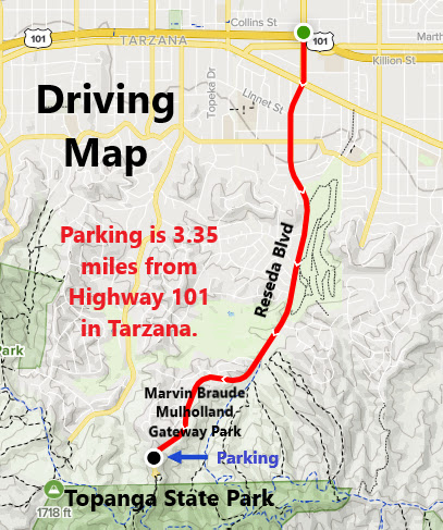
The hike begins at Marvin Braude Mulholland Gateway Park in Tarzana. After parking for free in the lower lot, I hiked up the road to the trailhead. The trail quickly connects with Mulholland Drive, which I ignored. I stayed on path and continued straight to the next junction with Temescal Canyon Fire Road. From there, I took a left to head slightly downhill to the SE. The roadway passes the Garapito Trail (which will be part of the return route). Meanwhile, the road continues to Hub Junction, which will be a major junction on the way back.
The high point of Cathedral Rocks.
While continuing straight, I made a quick side visit to Cathedral Rocks. I sat on top after a brief rock climb. From there, the road continued south to Temescal Peak.
The summit of Green Peak.
After a brief visit to Temescal Peak, I continued south to the next significant high point on Green Peak. Radio towers mark the summit with good views toward the coastline. Since my plan was to hit the high peaks in the upper portion of Topanga State Park, this was my turnaround point. I headed north from here and returned to Hub Junction. This time, I turned left on the Backbone Trail and headed over to Eagle Rock. Meanwhile, I topped out an a few unnamed high points just off the trail and along the way.
Heading toward Eagle Rock.
Eagle Rock sits on a rocky perch a little bit off the trail. The prominent high point has great views and is a nice spot to hang around. Since I still had a long way to go, I kept going. I returned to the Backbone Trail and went east. The Garapito Trail is accessible almost right away. The Garapito Trail is a single track trail with an abundance of shade. The trail dips into a canyon before climbing out a few miles later at a junction with Temescal Canyon Fire Road (as seen early in the hike). From there it is a matter of following the road back to Marvin Braude Park.
Onyx Summit is the highest point on Highway 38. It is also a good starting point for three nearby peaks. The obvious one, Onyx Peak, is right behind the parking area. However, to get started on the hike to Lightning Gulch Point involves carefully crossing the highway and continuing on a rocky dirt road. The trail is perhaps the rockiest and most difficult in the first mile, but thereafter, the climb is rather gradual the rest of the way. The pine trees are not very tall in this area, but many are wide and sturdy. The hike extends near the cliff's edge at times, but the ample tree cover keeps distant views to a minimum.
On the summit of Lightning Gulch Point.
After a steady climb, the trail drops into a draw with a steep rocky road climb to follow to the summit. The summit is marked with an unusual marker. The summit is wide and rounded, but the views aren't as great as expected since the trees around the edge of the summit block many of the viewpoints.
Heading to Peak 9385.
Instead of turning around there, I continued on to Peak 9385, which is less than a mile beyond. Most of the hike there was on retired four wheel drive roads. When getting close to the peak, I let the high point be my visual guide. The summit was marked with a summit cairn. This is a very remote spot, and I felt the need to hang out there for a little while and enjoy the moments. Afterwards, I retreated along the same route.
To the east of Wrightwood on Angeles Crest Highway, there is the Sheep Creek Bridge. To the east of the bridge is a wide pullout right at the southeast slope of East Table Mountain. Cross the creek bed here and look for a use trail going right up the slope. The trail was relatively straightforward on my visit, with no bushwhacking necessary. It connects with a road which continues going up. It continues to an area a little below the summit. At this point, the road bends to the right and goes away from the high point.
Getting close to the high point.
That's where I picked up a rather clear use trail which continued the climb to the top. A wide grassy summit is marked with a pile of rocks on the highest point. Good views from the summit of all the surrounding peaks (which are all higher than East Table Mountain). However, height isn't the main draw. This is a very secluded spot rarely visited by other hikers.
From Tenaja Road, I parked about 2.5 miles south on Margarita Road. There is a shady oak grove with a pullout good for parking. It seemed better to leave my vehicle in the shade on a hot day rather than pressing forward on a dubious road and parking it along the side.
A nice place to park.
I began hiking from there while heading south on the dirt road. The walk is about a mile before reaching the actual trailhead at a vehicle gate. I turned left here and took this side road about a half mile to a signed junction. A right here follows a trail up slope.
Looking up slope.
Some sections are bit overgrown but leads toward the high points. The first one is a false summit with a large tree on top. Beyond, and through the bushes, is the true summit. A rock pile marks the summit, with great views into Camp Pendleton Marine Base. Return the same way. Margarita Lookout is further down the road from where the Margarita Peak Trail began, and is an optional addition to the hike. Although the technical stats make this an easy hike, navigation can be difficult to discern. Looking for clues for use trails as you go is the key to getting you to the summit. Although it doesn't seem like it, the peak and trail are actually in the far northern corner of San Diego County, although the closest city is in Riverside County.
The Three T's, Thunder, Telegraph, & Timber, makes up one of the more storied hikes for San Gabriel Mountain peak baggers. Oddly, the reason is because they all start with the letter "T", so completing each on a single hike makes for a neatly packaged hiking adventure, complete with a catchy name. Despite that, the hike actually does live up to expectations. In reality, there are a few other peaks in between, so a well planned hike can net about 6 total peaks without venturing too far off trail. The prospect of claiming so many peaks in one shot would undoubtedly get the serious hiker's ears to perk up. After all, the hike is doable for any non-technical hiker who wants to put forward the effort.
On the summit of Thunder Mountain.
Completing the Three T's can be done in at least 3 different ways. One way is to start in Icehouse Canyon and performing an out and back to the three peaks, another is an out and back from the Mt Baldy Ski Lift. The third way is by doing a grand loop beginning and ending at Manker Flats. Each has its benefits and drawbacks. The one that suited me the most was the plan that starts and ends at the Mt Baldy Ski Lift. This one got me to the three T's sooner, however, the drawback was that it took longer to get back (but I was OK with that).
Telegraph Peak
From the ski lift parking lot, a gated dirt road goes up the western side of the lot to the dirt portion of Mt Baldy Road. The road continues uphill to the ski lodge at Baldy Notch. Just beyond the resort area, the trail splits. Mt Baldy hikers go left and Three T's hikers go right. In 1.3 miles, the trail accesses the first "T" of Thunder Mountain. Telegraph Peak is next, but it is reachable after a steep climb. Teleraph Peak is the highest point in the hike. Timber Mountain is last, but comes after a long up and down climb. Along the way, Rees Point and Smetana Hill are two notable peaks that are available to bag along the way.
On the summit of Telegraph Peak.
Once reaching Timber Mountain, the "T" peak trifecta is completed. If completing the loop, you keep going forward to Icehouse Canyon. However, on the out and back plan, you would need to climb back over Telegraph Ridge and Thunder Mountain.
Timber Mountain.
After making this long return, I managed to snag one more peak known as Gold Ridge, which is just off the road between Thunder and Baldy Notch. From there, it is downhill all the way back, and then conquest of the Three "T"'s was mine!
From the Mt Wilson entrance gate, Mt Wilson Toll Road is accessed. This old paved road descends to an entrance gate to Mt Harvard, adjacent to the single track Mt Wilson summit trail. Go left before reaching the gate and continue on the road. This bypasses Mount Harvard and leaves it for later in the hike. The paved road is no longer a thing at this point, so the hike remains on the rocky dirt road. The hike passes and ignores the Winter Creek Trail on the way down. Shortly past this junction, Mt Yale comes in view. In about 3 miles, the road arrives at Harvard Saddle, which is in between Mt Yale and Mt Princeton. A right turn begins ascending Harvard Ridge toward Mt Yale.
Approaching Mt Yale.
The use trail gets overgrown, but using the high point ahead as your target is the way to do it when in doubt. The trail eventually tops out on the summit of Mt Yale, which has a benchmark.
Mt Yale Benchmark.
The trail continues forward to Mt Harvard from there. It is slow going and steep in parts, but along the way, the trail meets man made structures associated with the summit tower facility. This is a way of letting you know that you are close to the top. Eventually, the trail rises to the summit which has a large building to go with the towers.
Approaching the summit of Mt Harvard.
The trail connects with the summit road that drops to the gate that was seen earlier in the hike. At first it seems like you are locked in, however, there is no side fence, so you simply swing around the side of the gate and you are back on Mt Wilson Toll Road.
On the summit of Mt Harvard.
It is about a 1 mile climb from there back to the parking area near the Mt Wilson entrance gate.