Purpose of the site

This blog will detail 1,000 video hikes in Southern California. By Southern California, I am drawing a line from San Luis Obispo to the Nevada Border. Anything south of that line will be declared "Southern California". In a way, it is a personal challenge to do so many hikes. Mainly, however, it is my way of showcasing how many hiking opportunities there really are right in our own geographic back yard. As a blog, it serves as a companion piece to my Youtube channel "Mike On The Trail". It is also a work in progress, as I don't actually have 1,000 edited videos completed. This will take effort for quite some time before it is declared done. Even then, there will still be more out there. Here's to hiking and all the positive effects it has had on my life...and possibly yours!

Saturday, June 11, 2022

#124 Ontario Peak

Looking toward Ontario Peak after passing Icehouse Saddle.
Southern California Map.
Driving Map.
Parking coordinates: 34.2278°N, -117.6239°W.
Hiking Stats:
Hiking Map.
Summary
Icehouse Canyon is the gateway to some of the highest peaks in the San Gabriel Range. Ontario Peak is one of these options. I personally prefer to give each major Peak it's own day, rather than combining them all on the same hike.
Approaching Ontario Peak.
Because if that, I still need to go back to video Cucamonga Peak and Bighorn Peak, when the time comes. Both are neighboring peaks with their own unique final approach. 
Bighorn Peak.
Each Peak requires ascending the rock filled Canyon to reach Icehouse Saddle. From there, the hiked ng route breaks off into four directions. For Ontario Peak, I turned right and continued elevating to Ontario Ridge. On the ridge, Bighorn Peak is to the left, while Ontario Peak is still not visible yo the right.  I turned right and elevated on the ridge.
Ontario Peak summit.
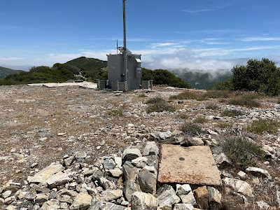
I passed "Fake" Ontario Peak (which I visited on the way back). Beyond, the true summit appeared. I managed to reach the summit soon after, where a large hiking group was congregating. I managed to get my summit time, though.
Getting ready to visit "Fake" Ontario Peak.
I returned the same way, for a typical long and rugged outing that accompanies any visit to Icehouse Canyon. 
Returning through Icehouse Canyon.
Video:
Simulated Hike:


Saturday, June 4, 2022

#123 Cajon Mountain

Heading up the road toward Cajon Mountain.
Southern California Map.
Driving Map.
Parking coordinates: 34.27244°N, -117.42°W.
Hiking Stats:

Hiking Map.
Summary
Coming freshly off of my Sugarpine Mountain visit on my previous hike, the ascent of Cajon Mountain came up the opposite slope to the North. I utilized the same forest road which comes up from Silverwood Lake State Recreation Area.
Taking the Cajon Mountain summit road.
In my younger days, I actually drove up the rough road from Silverwood.  However, this time I wanted to hike the entire way to the summit. That's supposed to be what hikers do, after all! 
Cajon Mountain Lookout.
The hike is on the dirt road all the way to the junction with Cajon Peak. I was glad I hiked it, since I only encountered a few cars on a generally peaceful hike.  The Cajon Peak junction is gated and can only be accessed on foot or Mountain bike. So even drivers would need to set off on foot from there. I hiked it to the end of the road to reach Cajon Lookout.
Approaching Cajon Mountain High Point.
The summit has foundations and a small summit structure. There is also great views into the Cajon Pass. While turning back around, there is a summit trail that goes to the true summit of Cajon Mountain. I needed to bushwhack much of the way.
Cajon Mountain summit.
Views were not as good from this true summit. It was a long walk back from there, but at least it was downhill all the way! 
Appreciating the mountain views on the way back.
Video:
Simulated Hike:

#125 The Flagpole Hill Loop

Clearly, this was Flagpole Hill. Southern California Map. Driving Map. Google Maps Trailhead Link Parking coordinates: 33 .48027 °N, -117.65...