This blog will detail 1,000 video hikes in Southern California. By Southern California, I am drawing a line from San Luis Obispo to the Nevada Border. Anything south of that line will be declared "Southern California". In a way, it is a personal challenge to do so many hikes. Mainly, however, it is my way of showcasing how many hiking opportunities there really are right in our own geographic back yard. As a blog, it serves as a companion piece to my Youtube channel "1,000 Hikes in So Cal". It is also a work in progress, as I don't actually have 1,000 edited videos completed. This will take effort for quite some time before it is declared done. Even then, there will still be more out there. Here's to hiking and all the positive effects it has had on my life...and possibly yours!
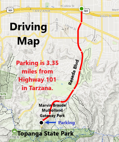
The hike begins at Marvin Braude Mulholland Gateway Park in Tarzana. After parking for free in the lower lot, I hiked up the road to the trailhead. The trail quickly connects with Mulholland Drive, which I ignored. I stayed on path and continued straight to the next junction with Temescal Canyon Fire Road. From there, I took a left to head slightly downhill to the SE. The roadway passes the Garapito Trail (which will be part of the return route). Meanwhile, the road continues to Hub Junction, which will be a major junction on the way back.
The high point of Cathedral Rocks.
While continuing straight, I made a quick side visit to Cathedral Rocks. I sat on top after a brief rock climb. From there, the road continued south to Temescal Peak.
The summit of Green Peak.
After a brief visit to Temescal Peak, I continued south to the next significant high point on Green Peak. Radio towers mark the summit with good views toward the coastline. Since my plan was to hit the high peaks in the upper portion of Topanga State Park, this was my turnaround point. I headed north from here and returned to Hub Junction. This time, I turned left on the Backbone Trail and headed over to Eagle Rock. Meanwhile, I topped out an a few unnamed high points just off the trail and along the way.
Heading toward Eagle Rock.
Eagle Rock sits on a rocky perch a little bit off the trail. The prominent high point has great views and is a nice spot to hang around. Since I still had a long way to go, I kept going. I returned to the Backbone Trail and went east. The Garapito Trail is accessible almost right away. The Garapito Trail is a single track trail with an abundance of shade. The trail dips into a canyon before climbing out a few miles later at a junction with Temescal Canyon Fire Road (as seen early in the hike). From there it is a matter of following the road back to Marvin Braude Park.