This blog will detail 1,000 video hikes in Southern California. By Southern California, I am drawing a line from San Luis Obispo to the Nevada Border. Anything south of that line will be declared "Southern California". In a way, it is a personal challenge to do so many hikes. Mainly, however, it is my way of showcasing how many hiking opportunities there really are right in our own geographic back yard. As a blog, it serves as a companion piece to my Youtube channel "1,000 Hikes in So Cal". It is also a work in progress, as I don't actually have 1,000 edited videos completed. This will take effort for quite some time before it is declared done. Even then, there will still be more out there. Here's to hiking and all the positive effects it has had on my life...and possibly yours!
It is a relatively short hike to reach Townsend Peak. That's what makes it a great add on hike after hiking nearby Whitaker Peak. Unlike Whitaker, however, this nearby peak is much greener with lush plant growth. A hike here is more scenic as well. The hike is essentially a climb on a dirt road to the summit. At the end, it requires a short scurry off the road to reach the summit. I found no summit markers on top.
On the ridge.
There is a nearby twin summit about a half-mile away, so I climbed it as well. Sometimes peak climbing involves hedging your bets a bit by climbing all nearby high points in order to be sure that you actually climbed the proper peak. By doing both, I had no doubt that I completed the task. I returned the same way to close out the visit. Despite being right next to Interstate 5, I had both trails to myself, with the exception of a mountain biker or two.
Summary Whitaker Peak is one of a handful of hikes accessible from Golden State Highway. GSH is the old roadway bed that went through the canyon before Interstate 5 was built. The hike begins at a signed roadway that elevates above the canyon. I parked near the start of the hike and hiked past the locked vehicle gate. The road is in good shape, and is probably only open for service vehicles. There is also little to no shade on the hike, so it is best to visit on a cool day.
Approaching Whitaker Peak.
The semi-paved road leads out to buildings with radio towers overlooking the Sespe Wilderness at Whitaker Lookout. Although it is at the end of the road, this isn't the actual Whitaker Peak summit. To get to it, I had to backtrack to a point where I could go cross country (with a faint use trail) to the actual summit. The summit has a benchmark.
Summit benchmark.
Afterwards, I retreated back to the road. I followed the road all the way back for 4 miles. Although the hike involved claiming two peaks, I still had the desire to do more, so I drove down the road to take on the Townsend Peak hike as well.
Not to be confused with the more popular and taller mountain of the same name in Northern California, this is one of the smaller outlying peaks in the San Gabriel Mountains. This doesn't mean that it is an easy climb, though. In fact, there is no established trail getting to it. Where Swarthout Canyon Road meets Lone Pine Canyon Rd, there is a parking area at the junction.
Approaching the summit.
From the parking area, Ralston Peak stands tall to the east. To get to it, I cut straight across an untrailed field to an old overgrown dirt road. I followed the dirt road North as it started to go around the side of the peak. When the peak crossed a dry creek channel, I left the mostly overgrown road and took the creek toward a deep gully on the lower slopes of the mountain. Once heading deeper into the gully, I looked and found a route of least resistance up a lower slope. This connected me with a rising ridgeline which continued all the way to the summit. Somewhat of a use trail followed the exposed ridge along the way.
On the summit of Ralston Peak.
The summit is wide and has a register. I believe I was the second person to sign the register for the year. Therefore, not much traffic up this peak. Great views extend over Cajon Junction and Interstate 15 through the Cajon Pass. Despite the hustle and bustle below, this is a quiet and peaceful spot. I returned the way I came, and also included the lower peak to the west known as Peak 4003. I merely extended the lower slope to reach it. Afterwards, I headed down the gully and back to the parking area. Littler known or untrailed peaks can be hikes too!
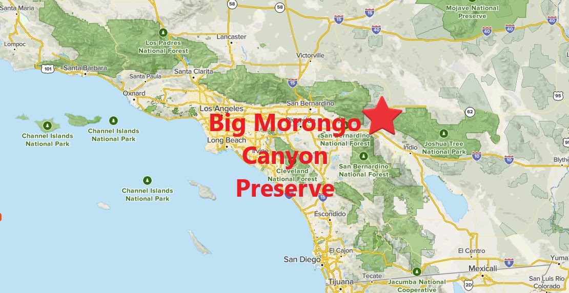
Summary Sure, you're in the desert, but Big Morongo Canyon certainly doesn't seem like it. Thanks to the Morongo Fault, there is a water source sitting out in the open. Over the years, water thriving trees and plants have grown around it and formed a lush desert jungle. After nature took care of that, pathways were built through the preserve which creates a unique desert hiking experience.
Strolling along the boardwalk.
A trail system loops around the preserve floor. An additional trail extension climbs above the preserve and gives good views down into it. In wet years, this is a very green place, with nice pools of water. In dry years, it is not usually quite as green, but still it is a great place to take a walk. This is also a great gathering spot for birds and bird watchers.
More of the same, yet it never gets old.
Behind the preserve is the rest of the canyon. The canyon is not quite as lush, but it is possible to walk through the canyon all the way to Indian Canyon Drive near Desert Hot Springs. This canyon extension to the hike may have private property restrictions, though. I was lucky enough to do it once before, but changes happen, and it is best to always be prepared to act accordingly when on site.
Summary Whitewater Preserve sits in an usual and generally unstable location in the San Bernardino Mountain foothills. It is unstable, since the area sits within the Whitewater drainage zone. If water flows heavily through the canyon, then the road gets closed and so do the hiking trails. Otherwise, the landscape is rather dry and desert like, as it is also in the desert transition zone. From the parking lot, I made a left next to the parking lot entrance, where the signed trail begins. It starts out on a maintained pathway before crossing through the rocky river channel. Once across the channel, the trail connects with the Pacific Crest Trail and stays on the left side of the river channel.
Approaching Forks Benchmark on the PCT.
At about 2.5 miles in, the trail reaches cliffsides adjacent to Red Dome. Red Dome is nothing more than a giant red boulder sitting in the river channel. It is worth a visit, with an easy scramble to its top. I concentrated more on the cliff wall, where a use trail goes up its side. Once on top of the cliffs, a use trail continues to a higher point. Some minor bushwhacking brought me to the summit of Forks Benchmark. I found the benchmark and took in the views. Looking up the ridge, I could see a somewhat direct route further up the ridge to Nob Benchmark about 1.5 miles away. I didn't come out there expecting to climb Nob Benchmark, so I made sure to take note of it for a future hike.
On the summit of Forks Benchmark.
I returned back to the trail after visiting Forks Benchmark and returned to the parking lot to complete a quick visit. The weather was perfect, but I felt a little disappointed by not continuing to Nob Benchmark. However, I was a little pressed for time. I will definitely be back someday to extend the hike further next time, and also wipe away a little bit of the "hiker's guilt" that I inadvertently created for myself on the visit.
Summary The hike begins in a well-to-do Palm Springs neighborhood. It climbs quickly into the hills above. Once leveling off, it is possible to form a loop on the plateau, which I did. I saved Cahuilla Peak for last, which was just to the left of the intersection of trails. I went right on the Wildhorse Trail to begin the loop. The first peak reached was Wildhorse Peak. The trail heads up its rocky ridge to a prominent summit. The feeling of accomplishment was brief when looking at the rest of the ridge laid out in front.
Palm Springs views.
The Wildhorse Trail continues on the ridge toward Murray Hill. A left turn on the Clara Burgess Trail becomes necessary along the way. The hike rises from the junction to the summit of Murray Hill. On top are picnic tables, a benchmark, and great views. The prominent high point is a great resting spot for a quick snack before heading on.
Wildhorse Peak.
I chose to continue forward to form a loop, rather than returning the way I came. The trail drops quickly toward the canyon floor before continuing on to Cahuilla Peak.
Murray Hill.
I found the trail to not be too well marked in the canyon, but I eventually figured out the right pathway to take. Arrival at Cahuilla Peak, and to the junction just beyond it, marked the completion of the long dry loop of the ridge and canyon floor. After the loop, I still needed to descend to Palm Springs to close out the hike. Fortunately, I didn't run out of water, but I came close!