This blog will detail 1,000 video hikes in Southern California. By Southern California, I am drawing a line from San Luis Obispo to the Nevada Border. Anything south of that line will be declared "Southern California". In a way, it is a personal challenge to do so many hikes. Mainly, however, it is my way of showcasing how many hiking opportunities there really are right in our own geographic back yard. As a blog, it serves as a companion piece to my Youtube channel "1,000 Hikes in So Cal". It is also a work in progress, as I don't actually have 1,000 edited videos completed. This will take effort for quite some time before it is declared done. Even then, there will still be more out there. Here's to hiking and all the positive effects it has had on my life...and possibly yours!
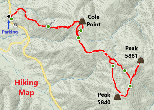
Near mile marker 7.10 on Angeles Forest Highway, I walked up a dirt road heading east. The dirt road continued for about 0.4 miles before reaching a use trail on the left. The use trail climbs the lower slope of Cole Point. It is a short but steep climb up the trail, which occasionally disappears along the way. However, the direction of "up" is pretty clear, so it is easy to stay on track despite the inconvenience of the occasional cross-country scrambling. The summit of Cole Point is reached in about 1.5 miles. On my visit, the summit had been recently bulldozed as part of a firebreak project in the San Gabriel Mountains.
On the summit of Cole Point
Although this is the main peak to visit on the hike, there are still two more within hiking distance. I took up the challenge and went on to get them both. They are visible from Cole Point to the east. I continued along new firebreaks toward them. The first up was Peak 5840. A very steep ascent was necessary along the no nonsense firebreak. A witness post marks the summit.
On the summit of Peak 5840.
The next peak over, Peak 5881, is the final peak on the hike. To get to it involves a long dip on the firebreak followed by a steep climb to the summit.
Approaching Peak 5881.
Despite being the high point on the hike, the freshly bulldozed summit seemed more like a construction site. Despite that, the area seemed far removed from people. Once again, I chose another remote and seclusive location (no regrets). It is not the most scenic of areas, but the fresh air certainly helps. On the way back, there is some climbing to get back up Cole Point, however, once there, it is downhill all the way back down to Angeles Forest Highway.
Much like nearby Parker Mountain, Peak 4440 is on the desert edge of Angeles National Forest. The hike begins at a locked vehicle gate and accesses a road that appears to be used for powerline maintenance. The trail passes through a scenic creek-side grove in a small canyon before it rises above it on the other side. Dusty plains lie beyond and on the way to the peaks ahead.
Approaching Peak 4440.
In about 1.5 miles, there is a four way junction. Turn left at the junction and follow the road as it climbs along the slopes toward Peak 4440. There are actually two peaks in close proximity, but Peak 4440 is the higher one and on the right. As the road flattens out at the saddle, I left the road on a peak use trail. The trail gradually elevates to the summit which is marked by a metal witness post. I found this hike to be very peaceful and remote. I saw nobody out there and never expected to. Such are the benefits of experiencing obscure hiking destinations. Let all the hikers on popular trails rub elbows, you got this one all to yourself!
From Hubbard Road, the hike starts by walking up Hughes Canyon Road. In about a half-mile, there is a road split. The left fork goes toward Parker Mountain. The road rises along a ridge with good views toward Parker Mountain. With the destination in view for most of the hike, it is just a matter of getting to the end. The ridge hits a few high points along the way, before a summit trail breaks off from the road and climbs directly to the summit. On top is a building foundation for the former fire lookout, a summit sign, and a benchmark.
Approaching Parker Mountain
On the way back, I followed the same route along the ridge. When back at the first junction, I made a left and then quickly picked up a trail climbing to the right. This quickly leads to Ravenna Benchmark. The relatively short hike is good for two summits, making it an ideal peak bagging outing while the weather is still cool.
Mount Marie Louise is down the road from The Pinnacles hike, which I completed earlier in the day. The trail starts off Pilot Rock Road, which is a dirt road often utilized by ATVs. Shortly before a creek crossing on the road, I bailed out and parked in the non-high clearance parking area. This added an additional 2 miles round trip to the hike. It was a mostly flat two miles, though while hiking on the dirt road (and not risking damage to my car). This also allowed me to easier find where the actual hike begins, which is marked only by a small cairn (and easy to miss) on the side of the road.
At the base of Mount Marie Louise.
Once picking up the trail, you will see right away that this isn't your traditional pathway. When looking closely, you can see rock ducks (small cairns) further ahead which continues into a gully. The way forward remains in the gully until reaching the base of Mount Marie Louise. Meanwhile, there is quite a bit of boulders climbed over or maneuvered around while in transit. With persistence (and remaining in the gully), the trail will reach an edge of the gully where the summit trail is accessed.
Heading up the side.
The summit trail is overgrown in spots, but the route is generally easy to follow, although it climbs rather steeply up the slope. Summit boulders are multiple. It took a few careful moves to stand on the highest one. Great views of the surrounding landscape is the payoff for the effort taken.
The hike begins at a prominent trailhead sign down the road from a shooting range. There is a moderate sized parking area at the trailhead. Fortunately, the trail bypasses the shooting range and passes through the boulder filled hills. It is easy to get off track and wind up taking the wrong path at times. In some cases, your best judgement comes in play. The main pathway will continue through the canyon and around some boulder filled slopes. It reaches a small pass with distant views to the north.
View of The Pinnacles
A slight downhill walking begins here. This is where The Pinnacles comes in view. The prominent boulder filled peak ahead is the destination. The trail leads to its base, where a use trail continues up its slope. The peak trail is rocky and steep, but it is a short climb. It is also a ducked trail, which helps quite a bit. Boulders sit on top. A few good moves will get you standing on the top boulder and claiming the peak. Great views in all directions!
Since Chino Hills State Park has many access points, there is more than one way to do this loop. The starting point that I find most useful for this hike is from Rimcrest Drive in Yorba Linda. It is a short walk from parking on the street to a free park entrance next to homes. The trailhead crosses the South Ridge Trail via the Easy Street Street Trail, which goes north toward Telegraph Canyon. Along the way, Gilman Peak is the visible high point in the hills ahead. Once accessing Telegraph Canyon, I turned right and looked for the peak access trail on the left (which appears after about a half mile on Telegraph Canyon. Once picking up the Gilman Trail, the hike begins climbing toward the peak. This is when views begin opening up. Once reaching the summit, I found a post and a benchmark and some good views (the peak is reached in 2.1 miles).
A flowery ascent.
When ready to leave the summit, I kept going forward and connected with the North Ridge Trail. A good amount of time is spent continuing eastward toward Five Points Junction. Fortunately, in the spring time, there are abundant wildflowers to see along the way (at least it was for me). Otherwise, there are good views of the rolling hills and open spaces as you go (regardless of the time of year). Five points gets reached about 3 miles beyond Gilman Peak. The site has a covered picnic table and a porta potty station. The Bovinian Delight Trail gets picked up there and continues to the South Ridge Trail. Once on the South Ridge, a left turn and about 0.4 miles of walking takes you to San Juan Hill (the highest point in Chino Hills State Park).
On the summit of Gilman Peak.
San Juan Hill is a good place to pause and take in the views (both natural and city views). When ready to continue with the loop, backtrack from the peak onto the South Ridge Trail and follow the roller coaster like hike back to Rimcrest Drive. Truly a satisfying hike within some of the last remaining open spaces around.


